Filter: Categories of Wisconsin Historical Images
Filter: Subject of Mississippi River
Filter: Subject of waterfalls
Filter: Categories of Wisconsin Historical Images
Filter: Subject of Mississippi River
Filter: Subject of waterfalls

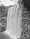
| Date: | 1884 |
|---|---|
| Description: | Illustration of the Falls of St. Anthony, as seen in The Indian Tribes of the United States: their history antiquities, customs, religion, arts, languag... |
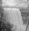
| Date: | |
|---|---|
| Description: | Elevated view of St. Anthony's Fall. Caption on back of stereograph reads, "St. Anthony's Falls, Minneapolis, Minn." There is a bridge in the foreground, a... |

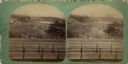
| Date: | |
|---|---|
| Description: | View across Saint Anthony Falls with St. Paul in the background. |

| Date: | 1783 |
|---|---|
| Description: | This map is hand-colored and shows the boundaries of British, Spanish, and the newly recognized American claims, as well as the fishing rights granted to F... |

| Date: | 1760 |
|---|---|
| Description: | Map showing the towns, mountains, valleys, corn fields, and rivers of a portion of the Cherokee Nation. A few annotations on the map explain the land and r... |

| Date: | 1755 |
|---|---|
| Description: | Map of the Great Lakes region during the French and Indian War. It shows in great detail the territories, borders and boundary lines, Native American tribe... |
If you didn't find the material you searched for, our Library Reference Staff can help.
Call our reference desk at 608-264-6535 or email us at: