 Filter: Categories of Wisconsin Historical Images
Filter: Subject of Mississippi River
Filter: Subject of land
Filter: Year of 1800-1899
Filter: Categories of Wisconsin Historical Images
Filter: Subject of Mississippi River
Filter: Subject of land
Filter: Year of 1800-1899
| Date: | 1858 |
|---|---|
| Description: | In August 1858, Hölzlhuber traveled up the St. Croix River to Stillwater, Minnesota, on the steamship Winona. He noted the upper Mississippi's tribu... |
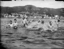
| Date: | 1890 |
|---|---|
| Description: | View across water towards men and boys swimming and splashing in the Mississippi River. Alma is in the background on the far shoreline. |

| Date: | 1856 |
|---|---|
| Description: | This landscape painting by Samuel Marsden Brookes and Thomas H. Stevenson depicts a broad view of the confluence of Bad Axe and Mississippi Rivers; site of... |

| Date: | 1856 |
|---|---|
| Description: | This map show the surveyed southern part of state and includes "profile of the Milwaukee and Mississippi Rail Road." Counties are shown in pink, green, blu... |

| Date: | 10 1829 |
|---|---|
| Description: | Fort Crawford as drawn by Seth Eastman. People are in a canoe in the river in the foreground. Across the river is the fort, other buildings around the fort... |

| Date: | 1803 |
|---|---|
| Description: | Cours du Mississippi : comprenant la Louisiane, les 2 Florides, une partie des Etats-Unis, et pays adjacents. |

| Date: | 1848 |
|---|---|
| Description: | In 1849, northern Wisconsin was composed of huge sectional regions such as Chippewa, Portage, Brown and Crawford, whereas southern Wisconsin was constitute... |
| Date: | 1840 |
|---|---|
| Description: | Photograph of a painting of the second Fort Crawford, built 1829-1835. Two men are in a boat in the water in the foreground. The first Fort Crawford at Pra... |

| Date: | 1868 |
|---|---|
| Description: | The sidewheel packet, Keokuk, loaded with passengers beside a barge at a landing. The landing is filled with people and horse-drawn vehicles. The si... |

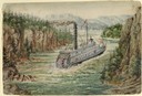
| Date: | 1872 |
|---|---|
| Description: | The sidewheel packet, Red Wing, in the Mississippi River near Queen's Bluff below Trempealeau, Wisconsin. |

| Date: | 1867 |
|---|---|
| Description: | Bird's-eye map of La Crosse with nine insets of residences, schools, and the Court House and Jail. |

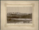
| Date: | 1880 |
|---|---|
| Description: | Bird's-eye map over the Mississippi River of Fountain City. Paddle steamers and steamboats are on the river, and bluffs are in the background. |

| Date: | 1848 |
|---|---|
| Description: | The first Fort Crawford at Prairie du Chien, with the Mississippi River in the foreground. Although dated 1830, this scene was actually painted by Henry Le... |
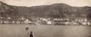
| Date: | 1883 |
|---|---|
| Description: | Man waving his hat in foreground with Alma, Wisconsin, visible in background across the Mississippi River. |

| Date: | 1829 |
|---|---|
| Description: | Drawing of Cassville depicting a horse cart on the river's edge, with men and boats. |
| Date: | 1886 |
|---|---|
| Description: | View of the Mississippi River from Alma. Caption reads: "Mississippi River. Ice Palace and Cyclone Views." |

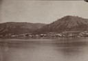
| Date: | 1875 |
|---|---|
| Description: | Aerial view of Alma along Mississippi River, with bluffs along the horizon. |
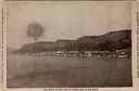
| Date: | 1890 |
|---|---|
| Description: | Mississippi River, with Alma in the distance, a typical river town which flourished in the 1850s. |
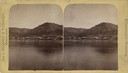
| Date: | 1890 |
|---|---|
| Description: | Stereograph of Alma from the Mississippi River. Text on front reads: "Wisconsin Scenery". |
If you didn't find the material you searched for, our Library Reference Staff can help.
Call our reference desk at 608-264-6535 or email us at:
