 Filter: Categories of Wisconsin Historical Images
Filter: Subject of Mississippi River
Filter: Creator Name of Unknown
Filter: Year of 1900-1999
Filter: Categories of Wisconsin Historical Images
Filter: Subject of Mississippi River
Filter: Creator Name of Unknown
Filter: Year of 1900-1999

| Date: | 1900 |
|---|---|
| Description: | The map is watercolor, pencil, and ink on tracing cloth and shows plats of both cities, local streets, railroads, mills, township divisions, bridges, and p... |

| Date: | 04 09 1936 |
|---|---|
| Description: | The Buffalo Head, a 'native' stone sculpture by the Mississippi River at the junction of Flint Ledge and Indian trails in Wyalusing State Park. The verso... |

| Date: | 1936 |
|---|---|
| Description: | Four men are building the wall at Signal Point Lookout in Wyalusing State Park. They are part of Works Progress Administration (WPA) Project #8656-8. Th... |

| Date: | 1972 |
|---|---|
| Description: | Before or after a Minnesota vs. Wisconsin Democrats softball game. Congressman David Obey holds up a concept rendering the future Richard I. Bong Memorial ... |

| Date: | 1910 |
|---|---|
| Description: | This map shows the Soo Line railroad and Arpin Hardwood Lumber Company lands in red. The top margin of the map reads: "Wisconsin, the safest state in the U... |

| Date: | 1900 |
|---|---|
| Description: | This set of photocopy bird's-eye-view maps include one view looking west from the top of Wisconsin River bluffs; and a second view looking east towards La ... |

| Date: | 1905 |
|---|---|
| Description: | Aerial view of Fountain City and the Mississippi River. Caption reads: "Fountain City, Wis." |

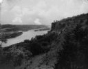
| Date: | 1905 |
|---|---|
| Description: | View of Fountain City from the Mississippi River. There is a steamer at the dock on the far shoreline. Hills in the background are reflected in the water. |

| Date: | 1910 |
|---|---|
| Description: | Elevated view of Fountain City, with the Mississippi River on the right, and hills in the background on the left. Caption reads: "Fountain City, Wis." |

| Date: | 1908 |
|---|---|
| Description: | View across the Mississippi River towards the city of La Crosse. Two riverboats are at the river's edge. Caption reads: "River Front and Harbor, La Crosse,... |
| Date: | 1902 |
|---|---|
| Description: | View of a tree-lined mountain across a body of water. Caption reads: "Trempealeau Mountain from across the bay." |
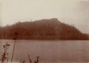
| Date: | 02 02 1927 |
|---|---|
| Description: | Elevated view of a cliff side overlooking a river. Caption reads: "Eagle Cliff, or Second Peak, in Perrot State Park. Donor Dr. Eben Pierce. Near Trempeale... |

| Date: | 1967 |
|---|---|
| Description: | Aerial view of what is identified by the caption as a "Nuclear power plant near Victory (Vernon Co.), Wis." This would be the La Crosse Boiling Water React... |
| Date: | 05 08 1927 |
|---|---|
| Description: | A crowd at Fort St. Antoine celebrating the 23rd anniversary of Nicolas Perrot claiming the territory of the upper Mississippi River for France. A reenactm... |
| Date: | 05 07 1927 |
|---|---|
| Description: | Actors taking part in a reenactment of a ceremony in which Nicolas Perrot claimed the territory of the upper Mississippi River for France at Fort St. Antoi... |

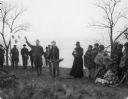
| Date: | 05 08 1927 |
|---|---|
| Description: | From left to right are E.D. Rounds, W.W. Bartell, and Joseph Schafer. They were participants in a reenactment of a ceremony in which Nicolas Perrot claimed... |
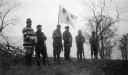
| Date: | 05 08 1927 |
|---|---|
| Description: | Six actors are standing outdoors. One of them men is holding a flag a fleur-de-lis design in a reenactment of a ceremony in which Nicolas Perrot claimed th... |
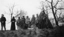
| Date: | 05 08 1927 |
|---|---|
| Description: | A group of actors, some in Native American clothing, are posing by an Indian lodge. They are participants in a reenactment of a ceremony in which Nicolas P... |
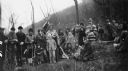
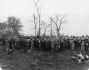
| Date: | 05 08 1927 |
|---|---|
| Description: | A large group of actors posing together outdoors while in costume. They are participants in a reenactment of a ceremony in which Nicolas Perrot claimed the... |

| Date: | 05 08 1927 |
|---|---|
| Description: | Actors performing in a reenactment of a ceremony in which Nicolas Perrot claimed the territory of the upper Mississippi River for France at Fort St. Antoin... |
If you didn't find the material you searched for, our Library Reference Staff can help.
Call our reference desk at 608-264-6535 or email us at: