 Filter: Categories of Wisconsin Historical Images
Filter: Subject of Mines and mineral resources
Filter: Subject of trails
Filter: Categories of Wisconsin Historical Images
Filter: Subject of Mines and mineral resources
Filter: Subject of trails
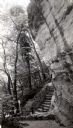
| Date: | 1945 |
|---|---|
| Description: | Tower Hill State Park trail leading to the top of the shot tower shaft. |
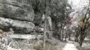
| Date: | 1945 |
|---|---|
| Description: | Tower Hill State Park trail to the top of the shot tower shaft. |

| Date: | 1837 |
|---|---|
| Description: | This map shows the townships, roads, trails, natural land forms, vegetation, mill sites and lead and copper deposits in the Wisconsin Territory at the time... |

| Date: | 1952 |
|---|---|
| Description: | This 1952 map of the northern parts of Bayfield and Douglas counties, Wisconsin, shows points established by E.T. Sweet in 1877, road points confirmed by S... |

| Date: | 1794 |
|---|---|
| Description: | Extremely detailed map of the south-eastern states, south from Virginia and east of the Mississippi River. It shows roads and paths, cities, towns, forts, ... |
If you didn't find the material you searched for, our Library Reference Staff can help.
Call our reference desk at 608-264-6535 or email us at: