 Filter: Categories of Wisconsin Historical Images
Filter: Subject of Mines and mineral resources
Filter: Subject of land use
Filter: Categories of Wisconsin Historical Images
Filter: Subject of Mines and mineral resources
Filter: Subject of land use
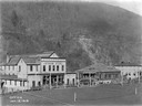
| Date: | 01 13 1919 |
|---|---|
| Description: | Office and company store. Benham was a "company town" created by International Harvester for the workers of the Wisconsin Steel Company. Wisconsin Steel wa... |
| Date: | |
|---|---|
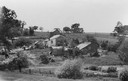
| Description: | Cornish miner's homes on a hill, with surrounding landscape. |
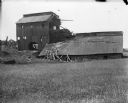
| Date: | 1909 |
|---|---|
| Description: | A deteriorating mining building seen from across a field. |
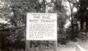
| Date: | 1945 |
|---|---|
| Description: | A marker at the former site of the smelter which stood at the top of the shot tower shaft. The sign reads: "Tower Hill State Park The Old Shot Tower At thi... |
| Date: | 1920 |
|---|---|
| Description: | The Empire zinc and lead mine. Very litle lead is now produced. |
| Date: | 1938 |
|---|---|
| Description: | Two men use a DR-60 truck owned by J. Robert Bazley, Inc. to dump coal taken from Pennsylvania coal strippings into a chute leading to railroad cars. The m... |

| Date: | 1948 |
|---|---|
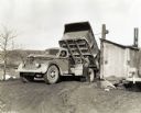
| Description: | An International KB-8-F dump truck owned by the Empire-Star Mines Company, Limited, parked in front of several buildings with its bed raised to ore(?). A m... |

| Date: | 08 15 1938 |
|---|---|
| Description: | A man standing with a dog near an International truck under a building owned by the Coshocton Black Coal Company. The company used PA-50 and 100K Morgan Ga... |
| Date: | 08 15 1938 |
|---|---|
| Description: | Buildings owned by the Peacock Coal Company. A man is standing beside a small wooden structure on the side of a hill. There is a ramp angling up and away f... |
| Date: | 01 19 1938 |
|---|---|
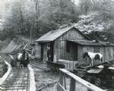
| Description: | Men and ponies standing near a building and carts on railroad tracks at the Story & McDade coal mine. The mine operation was powered by an International PA... |
| Date: | 09 1910 |
|---|---|
| Description: | People gathered around a horse-drawn buggy on the dividing line between the Ferris-Hagerty property and the Leighton-Wyoming mines. Harry Dankoler is to th... |
| Date: | 1925 |
|---|---|
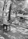
| Description: | An outdoor exhibit, possibly at Tower Hill State Park, with a display featuring a "pig of lead" found near the shot tower there. There is also a bronze pla... |
| Date: | 1900 |
|---|---|
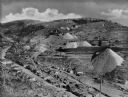
| Description: | Elevated view of Deadbroke Mining Company nestled in a valley. In the foreground are a small number of dwellings and roads, and cut lumber. Caption reads: ... |
| Date: | 1920 |
|---|---|
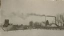
| Description: | Elevated view of a mining community, including numerous houses, mining structures, and large mounds of gravel material. |
| Date: | |
|---|---|
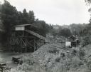
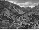
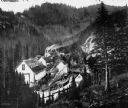
| Description: | Elevated view of Greenback Mining Company, located in a valley and surrounded by pine trees. There are mining buildings, a large house, and a man driving a... |

| Date: | 1925 |
|---|---|
| Description: | View across field towards large mounds of raw material at National Zinc Separating Company plant. Industrial buildings are in the background. |
| Date: | |
|---|---|
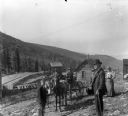
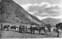
| Description: | View of a family posed before a pack train, heading toward the mines. |

| Date: | 1872 |
|---|---|
| Description: | This map, which includes eastern Iowa, northern Illinois and a portion of Michigan's Upper peninsula, shows the township survey grid and identifies countie... |

| Date: | 1866 |
|---|---|
| Description: | A map of Lafayette County, Wisconsin, showing the townships and ranges, sections, towns, villages, stream and rivers, mounds, mineral deposits and the Mine... |

| Date: | 1864 |
|---|---|
| Description: | This map is pen and watercolor on paper and shows profile and geological formation of Blue Mound and location of Arnold’s Hotel and Brigham Lead Mines. |
If you didn't find the material you searched for, our Library Reference Staff can help.
Call our reference desk at 608-264-6535 or email us at: