 Filter: Categories of Wisconsin Historical Images
Filter: Subject of Military bases
Filter: Reproduction Rights of For Sale
Filter: Categories of Wisconsin Historical Images
Filter: Subject of Military bases
Filter: Reproduction Rights of For Sale

| Date: | 08 13 1960 |
|---|---|
| Description: | Russian delegates to the seventh International Soil Science Congress are greeted at Truax Municipal Airport. Ann Borland (left), Miss Madison, greets Mrs. ... |

| Date: | 09 17 1960 |
|---|---|
| Description: | People from Mexico living in the Madison area gather along with their American friends at the Truax Field Officer's Club to celebrate Mexico's Independence... |

| Date: | 09 17 1960 |
|---|---|
| Description: | People from Mexico and their Madison friends gather at the Truax Field Officer's Club to celebrate Mexico's Independence Day. Dr. Gustavo del Castillo, phy... |

| Date: | 09 17 1960 |
|---|---|
| Description: | People from Mexico and their Madison area friends gather at the Truax Field Officer's Club to celebrate Mexico Independence Day. William Rosenbaum, a frequ... |

| Date: | 08 17 1960 |
|---|---|
| Description: | People from Mexico and their Madison area friends gather at the Truax Field Officer's Club to celebrate Mexico Independence Day. Some of the Mexican women ... |

| Date: | 1959 |
|---|---|
| Description: | Night view of the northeast gate of the U.S. base at Guantanamo. |

| Date: | 1965 |
|---|---|
| Description: | Large group of soldiers with packs and gear in a hangar. More packs and gear are near numbered areas in the foreground. |

| Date: | 11 1960 |
|---|---|
| Description: | View from side of road of a helicopter flying low over a hilly rural road with grass, wildflowers and trees at Guantanamo, Cuba. A chain link fence topped ... |

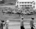
| Date: | 03 05 1965 |
|---|---|
| Description: | View across road towards a one-story building with three cars parked in front near the corner of E. Washington Avenue and N. Stoughton Road. The building w... |

| Date: | 1777 |
|---|---|
| Description: | Map showing the Hudson River in three sections, from New York City up through Lake Champlain, including cities, forts, roads, topographical features, and n... |
| Date: | 1967 |
|---|---|
| Description: | Men are walking in the foreground. In the background more men, in uniform, stand near several International Payscrapers parked in Phan Rang, Vietnam. Recen... |

| Date: | 1782 |
|---|---|
| Description: | Map of America east of the Mississippi River. It shows regions, state boundaries extending to the Mississippi River, cities, forts, Native American lands, ... |

| Date: | 1777 |
|---|---|
| Description: | Map of Colonial America east of Lake Michigan showing regions, cities, forts, Native American land, mountains, lakes, and rivers. Crossed swords and small ... |

| Date: | 1735 |
|---|---|
| Description: | Map of the Chesapeake Bay region and surrounding areas, with north oriented towards the right. A few forts, rivers, and bays are labeled, as are the region... |

| Date: | 1780 |
|---|---|
| Description: | Map of New York and parts of the neighboring states. It shows cities, forts, towns, roads, mountains, lakes, and rivers. several different boundary lines a... |

| Date: | 1760 |
|---|---|
| Description: | Map showing upstate New York, Lake Ontario, and the St. Lawrence River during the last, decisive battle of the French and Indian War. The main map shows a ... |

| Date: | 1780 |
|---|---|
| Description: | Detailed topographical and political map of the area from Lake Champlain to Albany and the Hudson River. Relief is shown through hachures. The map shows ci... |

| Date: | 1778 |
|---|---|
| Description: | Map of the land between Fort Ticonderoga and Albany. It shows cities, forts, mills, roads, mountains, swamps, waterfalls, lakes, and rivers. A few annotati... |

| Date: | 10 1776 |
|---|---|
| Description: | Broadside map showing the British invasion of New York city in August and September of 1776. The map shows important cities, forts, roads, hills, mountains... |

| Date: | 02 1777 |
|---|---|
| Description: | Map depicting the campaigns of October and November 1776, in Manhattan, Westchester, and part of New Jersey, published only a few months after the conclusi... |
If you didn't find the material you searched for, our Library Reference Staff can help.
Call our reference desk at 608-264-6535 or email us at: