 Filter: Categories of Wisconsin Historical Images
Filter: Subject of Michigan, Lake
Filter: Subject of rivers
Filter: Categories of Wisconsin Historical Images
Filter: Subject of Michigan, Lake
Filter: Subject of rivers

| Date: | 1937 |
|---|---|
| Description: | Bird's-eye view of Milwaukee in 1853 details building features and city layout from southwest. Important buildings are numbered in a silhouette drawing bel... |

| Date: | 1905 |
|---|---|
| Description: | Bird's-eye view of Manitowoc on the shores of Lake Michigan. A map of the northeastern part of the United States at the top indicates Manitowoc's location ... |

| Date: | 1892 |
|---|---|
| Description: | Bird's-eye view of Chicago, with ships in the Lake Michigan harbor. |

| Date: | 1632 |
|---|---|
| Description: | The Wisconsin portion of Champlain's 1632 map, augmented since the previous one, for navigation according to the true Meridien, by Sieur de Champlain. The ... |

| Date: | 1892 |
|---|---|
| Description: | Bird's-eye view of the Columbian Exposition pavilions from the vantage point of Lake Michigan. Included is an inset of the Union Passenger Station (now Uni... |
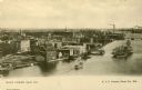
| Date: | 1925 |
|---|---|
| Description: | Aerial view of Green Bay, including the Jorgensen-Blesch Company building and two bridges. |
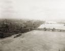
| Date: | 1920 |
|---|---|
| Description: | Aerial view of with bridges, river, and shoreline. |
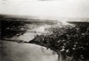
| Date: | 1900 |
|---|---|
| Description: | Elevated view of east Green Bay harbor with cargo ships, W.W. Cagill Co., and other various industries. |
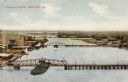
| Date: | 1910 |
|---|---|
| Description: | Elevated view of the harbor entrance. Caption reads: "Harbor Entrance, Green Bay, Wis." |

| Date: | 1844 |
|---|---|
| Description: | Map of Wisconsin including Lakes Michigan and Superior. Inset includes "N.W. Part of Wiskonsan." |

| Date: | 1941 |
|---|---|
| Description: | Official highway map of Wisconsin, "the playground of the Midwest," showing the state transportation network prior to World War II. |

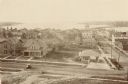
| Date: | 1950 |
|---|---|
| Description: | An aerial view of town, showing a major industrial area. |
| Date: | 1910 |
|---|---|
| Description: | Elevated view of various buildings with Sturgeon Bay in the background. |

| Date: | 1848 |
|---|---|
| Description: | Immigrant map. |

| Date: | 1865 |
|---|---|
| Description: | Map showing the location of meteorological stations and effects that Lake Michigan has had on Wisconsin temperatures in January and July. The map shows cou... |

| Date: | 1776 |
|---|---|
| Description: | In French: "Partie Occidentale du Canada et septentrionale de la Louisiane avec une partie de la Pensilvanie." A map showing graticule and six European sca... |

| Date: | 1835 |
|---|---|
| Description: | Constructed for the Topographical Bureau [Wash.], 1835. Scale: 16 miles to 1 inch. Map of a portion of the Indian country lying east and west of the Missis... |

| Date: | 1876 |
|---|---|
| Description: | Made from U.S. Surveys and from minutes furnished by Jos. S. Buck and Dr. C. Chase. Scale 20 CHs to an inch. |

| Date: | 1882 |
|---|---|
| Description: | This basic reference map of the state shows natural features, railroads, county seats, and political boundaries against the G.L.O. township and range grid.... |
If you didn't find the material you searched for, our Library Reference Staff can help.
Call our reference desk at 608-264-6535 or email us at:
