 Filter: Categories of Wisconsin Historical Images
Filter: Subject of Menominee Indians
Filter: Categories of Wisconsin Historical Images
Filter: Subject of Menominee Indians

| Date: | 1855 |
|---|---|
| Description: | This map depicts counties, creeks, rivers, lakes, railroads completed, railroads in progress, common roads and the Menomonee Reservation. |

| Date: | 1941 |
|---|---|
| Description: | Wisconsin counties, towns, cities, and selected villages, as well as the Menominee Indian Reservation are identified on this U.S. Bureau of the Census map ... |

| Date: | 1952 |
|---|---|
| Description: | This map shows counties, towns, cities, and selected villages, as well as the Menominee Indian Reservation are identified on this U.S. Post Office. Circles... |

| Date: | 1856 |
|---|---|
| Description: | This map with an ornamental border shows the township survey grid and identifies counties, named towns, cities and villages, rivers, lakes, railroads, road... |

| Date: | 1856 |
|---|---|
| Description: | This map of shows the township survey grid and identifies counties, named towns, cities and villages, rivers, lakes, railroads, roads, and the Menomonee an... |

| Date: | 1857 |
|---|---|
| Description: | This map depicts the township survey grid and identifies counties, named towns, cities and villages, rivers, lakes, railroads, roads, and the Menomonee and... |

| Date: | 1858 |
|---|---|
| Description: | This map of the entire state of Wisconsin depicts the township survey grid and identifies counties, named towns, cities and villages, rivers, lakes, railro... |

| Date: | 1859 |
|---|---|
| Description: | This map of the entire state of Wisconsin depicts the township survey grid and identifies counties, named towns, cities and villages, rivers, lakes, railro... |

| Date: | 1874 |
|---|---|
| Description: | This hand-colored map shows the railroads "completed" "in progress" and "contemplated" rivers, counties, cities and villages, and named towns in the state,... |

| Date: | 1873 |
|---|---|
| Description: | This hand-colored map of Wisconsin depicts the township survey grid and identifies counties, named towns, cities and villages, rivers, lakes, railroads, an... |

| Date: | 1875 |
|---|---|
| Description: | This hand-colored map of Wisconsin and the western portion of Michigan's Upper Peninsula depicts the township survey grid and identifies counties, named to... |

| Date: | 1900 |
|---|---|
| Description: | This map of shows the township grid, counties, cities and villages, lakes, rivers, rail lines and the Menominee Indian Reservation. |

| Date: | 1902 |
|---|---|
| Description: | This map shows the railroads of southern Wisconsin with the routes of the Chicago, Milwaukee, and St. Paul Railway traced in red. The township grid, counti... |

| Date: | 1910 |
|---|---|
| Description: | This map of northeastern Wisconsin shows the township grid, counties, cities and villages, lakes, rivers, rail lines and the Menominee Indian Reservation. ... |

| Date: | 1878 |
|---|---|
| Description: | A hand-colored, cloth mounted, sectional map of Wisconsin and the western portion of Michigan’s Upper Peninsula, showing the township grid, railroads, town... |

| Date: | 1880 |
|---|---|
| Description: | A hand-colored, sectional map of Wisconsin showing the township grid, railroads, counties, towns, cities, villages, and the Menomonee, Oneida, Flambeau, an... |

| Date: | 1882 |
|---|---|
| Description: | A hand-colored, sectional map of Wisconsin showing the township grid, completed and proposed railroads, counties, towns, cities, villages. The map also inc... |
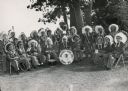
| Date: | |
|---|---|
| Description: | A group portrait of a band of Menominee Indians posing with their instruments. They are wearing feather headdresses. |
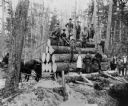
| Date: | |
|---|---|
| Description: | Group of twelve men and one woman posed with a load of logs waiting to be pulled by two horses harnessed to a sled. Several of the men hold cant hooks or p... |

| Date: | 09 17 1959 |
|---|---|
| Description: | A map of the Menominee Indian Reservation that shows the highways, different types of roads, rivers and streams in the area. |
If you didn't find the material you searched for, our Library Reference Staff can help.
Call our reference desk at 608-264-6535 or email us at: