 Filter: Categories of Wisconsin Historical Images
Filter: Subject of Menominee Indians
Filter: Subject of indian reservations
Filter: Subject of water
Filter: Categories of Wisconsin Historical Images
Filter: Subject of Menominee Indians
Filter: Subject of indian reservations
Filter: Subject of water

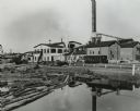
| Date: | 1910 |
|---|---|
| Description: | Sawmill on a Menominee Indian reservation, with logs floating in the water in the foreground. Caption reads: "Menominee Indian Mills." |
| Date: | 1950 |
|---|---|
| Description: | A sawmill run on the Menominee Indian Reservation. |
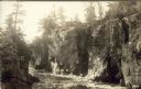
| Date: | |
|---|---|
| Description: | Postcard of Route 55 Menominee Indian reservation, Dells of Wolf River. |

| Date: | 1857 |
|---|---|
| Description: | A map of the state of Wisconsin and the southeastern portion of the Territory of Minnesota, showing the Wisconsin reservations of the Oneida, Menominee, St... |

| Date: | 1860 |
|---|---|
| Description: | A survey map of Wisconsin, southeastern Minnesota, and northern Iowa, showing the status of surveys, rivers, and lakes. The map also shows the locations of... |

| Date: | 1855 |
|---|---|
| Description: | This map shows the entire state and part of the Upper Peninsula of Michigan. It depicts creeks, rivers, lakes, railroads completed, railroads in progress, ... |

| Date: | 1855 |
|---|---|
| Description: | This Wisconsin map depicts counties, creeks, rivers, lakes, railroads completed, railroads in progress, common roads and the Menomonee Reservation. |

| Date: | 1855 |
|---|---|
| Description: | This map depicts counties, creeks, rivers, lakes, railroads completed, railroads in progress, common roads and the Menomonee Reservation. |

| Date: | 1941 |
|---|---|
| Description: | Wisconsin counties, towns, cities, and selected villages, as well as the Menominee Indian Reservation are identified on this U.S. Bureau of the Census map ... |

| Date: | 1952 |
|---|---|
| Description: | This map shows counties, towns, cities, and selected villages, as well as the Menominee Indian Reservation are identified on this U.S. Post Office. Circles... |

| Date: | 1856 |
|---|---|
| Description: | This map with an ornamental border shows the township survey grid and identifies counties, named towns, cities and villages, rivers, lakes, railroads, road... |

| Date: | 1856 |
|---|---|
| Description: | This map of shows the township survey grid and identifies counties, named towns, cities and villages, rivers, lakes, railroads, roads, and the Menomonee an... |

| Date: | 1857 |
|---|---|
| Description: | This map depicts the township survey grid and identifies counties, named towns, cities and villages, rivers, lakes, railroads, roads, and the Menomonee and... |

| Date: | 1858 |
|---|---|
| Description: | This map of the entire state of Wisconsin depicts the township survey grid and identifies counties, named towns, cities and villages, rivers, lakes, railro... |

| Date: | 1859 |
|---|---|
| Description: | This map of the entire state of Wisconsin depicts the township survey grid and identifies counties, named towns, cities and villages, rivers, lakes, railro... |

| Date: | 1874 |
|---|---|
| Description: | This hand-colored map shows the railroads "completed" "in progress" and "contemplated" rivers, counties, cities and villages, and named towns in the state,... |

| Date: | 1873 |
|---|---|
| Description: | This hand-colored map of Wisconsin depicts the township survey grid and identifies counties, named towns, cities and villages, rivers, lakes, railroads, an... |

| Date: | 1875 |
|---|---|
| Description: | This hand-colored map of Wisconsin and the western portion of Michigan's Upper Peninsula depicts the township survey grid and identifies counties, named to... |

| Date: | 1900 |
|---|---|
| Description: | This map of shows the township grid, counties, cities and villages, lakes, rivers, rail lines and the Menominee Indian Reservation. |

| Date: | 1902 |
|---|---|
| Description: | This map shows the railroads of southern Wisconsin with the routes of the Chicago, Milwaukee, and St. Paul Railway traced in red. The township grid, counti... |
If you didn't find the material you searched for, our Library Reference Staff can help.
Call our reference desk at 608-264-6535 or email us at: