Filter: Categories of Wisconsin Historical Images
Filter: Subject of Menominee Indians
Filter: Reproduction Rights of For Sale
Filter: Categories of Wisconsin Historical Images
Filter: Subject of Menominee Indians
Filter: Reproduction Rights of For Sale

| Date: | 1958 |
|---|---|
| Description: | The image shows a performer standing and holding a pipe. Member of the Peavey Falls group of dancers and musicians from the Menominee Indian Reservation in... |

| Date: | 1958 |
|---|---|
| Description: | Four generations of men and boys pose for a portrait of Menoninee Indians in full dress standing outdoors near a gate and fence. A sign says: "Indian Vill... |
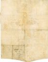
| Date: | 08 18 1821 |
|---|---|
| Description: | The reverse side of the Green Bay treaty, August 18, 1821. The treaty is signed by the chiefs of the six Indian nations for the possession of lands near th... |
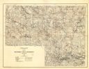
| Date: | 1929 |
|---|---|
| Description: | Map of the Menominee Indian Reservation. Legend reads: "Topographic and cultural data were obtained from field notes of a timber cruise and land classifica... |
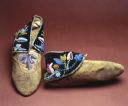
| Date: | |
|---|---|
| Description: | Men's buckskin moccasins. Puckered toes with purple cloth flaps that are patially decorated with floral pattern in seed beads. Sewn with the spot stich, bl... |
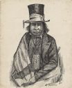
| Date: | 1850 |
|---|---|
| Description: | Waist-up pen and ink drawing of Chief Oshkosh. He is wearing a top hat wrapped with a ribbon. He wears a suitcoat, bowtie, beaded neckpouch and a blanket w... |
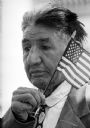
| Date: | 05 30 1961 |
|---|---|
| Description: | World War I veteran Edward J. Starr watches the Memorial Day service at the State Capitol while holding a small American flag. He is from a Menominee India... |

| Date: | 05 30 1961 |
|---|---|
| Description: | A Gold Star Mother shown holding her hand over her heart during the invocation at a Memorial Day service on the steps of the capitol. |
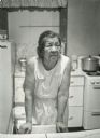
| Date: | 11 26 1970 |
|---|---|
| Description: | A candid portrait of Olivia King in her kitchen at their home on Rabbit Ridge on the Menominee reservation. |

| Date: | 1939 |
|---|---|
| Description: | This illustrated map shows counties, highways, rivers, roads, present and proposed state parks and forests, proposed state parkways, proposed state monumen... |

| Date: | 1956 |
|---|---|
| Description: | This map shows reservation boundaries, U.S. township lines, highways, roads, rivers, and lakes. The lower left corner of the map includes a legend of "Conv... |

| Date: | |
|---|---|
| Description: | View across water of a Menominee man standing in a canoe in a marsh. He is holding a paddle in his hand. Behind him on the left is another canoe with three... |

| Date: | 1907 |
|---|---|
| Description: | This blueprint map shows a proposed plan for pleasure roads and reservation system. It also shows schools, cemeteries, old river channel, proposed bridge, ... |

| Date: | 1930 |
|---|---|
| Description: | This map shows rivers, lakes, trails, Indian villages, distances, and boundaries of tracts ceded by the Munnomonee, Winnebaygoes, and New York Indians Trib... |

| Date: | 1970 |
|---|---|
| Description: | This map shows land owned by Menominee Enterprise Inc., land sold to Menominee shareholders, and land sold to non-Menominees. The map also includes water a... |

| Date: | 1846 |
|---|---|
| Description: | This map shows the plotting of the various townships in Wisconsin, both those that had been surveyed and some outlines for those which have not. A note in ... |

| Date: | 1914 |
|---|---|
| Description: | This map shows township grids, railroads, roads, and drainage. The area of the map covers northeastern Wisconsin and Menominee Indian reservation. Green Ba... |

| Date: | 1840 |
|---|---|
| Description: | This map is pencil on paper and shows rivers, granite locations, and selected landmarks. Relief is shown by hachures. |
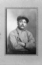
| Date: | 1915 |
|---|---|
| Description: | Waist-up seated studio portrait of Ernest Oshkosh (?1875-1929), grandson of Chief Oshkosh, son of Neopit. He is wearing a cap, bib overalls, and a striped ... |
If you didn't find the material you searched for, our Library Reference Staff can help.
Call our reference desk at 608-264-6535 or email us at: