 Filter: Categories of Wisconsin Historical Images
Filter: Subject of Maps
Filter: Year of 1900-1999
Filter: Reproduction Rights of For Sale
Filter: Type of Postcard
Filter: Categories of Wisconsin Historical Images
Filter: Subject of Maps
Filter: Year of 1900-1999
Filter: Reproduction Rights of For Sale
Filter: Type of Postcard

| Date: | 1905 |
|---|---|
| Description: | Bird's-eye view of Manitowoc on the shores of Lake Michigan. A map of the northeastern part of the United States at the top indicates Manitowoc's location ... |
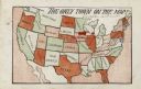
| Date: | 1905 |
|---|---|
| Description: | Map of the United States with an imprint of Whitewater, Wisconsin and the title "The Only Town on the Map". It was published as a novelty. |

| Date: | 1910 |
|---|---|
| Description: | Aerial view of some of the 26 lakes known collectively as the Chain O' Lakes. Caption reads: "Aeroplane View of Chain O'Lakes, Waupaca, Wis." |

| Date: | 1969 |
|---|---|
| Description: | Photographic holiday postcard of a couple on their bikes in a driveway. Shrubs and palm trees surround them. A map of the Pacific Ocean is in the backgroun... |

| Date: | 1966 |
|---|---|
| Description: | A colored map depiction of Door County, Wisconsin, with pictorial highlights, titled: "Door County — Wisconsin's Air Conditioned Peninsula Playground." |

| Date: | 1988 |
|---|---|
| Description: | Text on front, at the foot: "Wisconsin." The color image of Hyde's Mill has an overlay of a map of the southwest corner of Wisconsin inside a red frame. Th... |
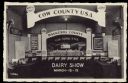
| Date: | 1940 |
|---|---|
| Description: | Text on reverse reads: "We invite you to attend Waukesha County Dairy Show. March 12-15, 1940. Sales Pavilion, Waukesha, Wis. Judging days, March 13-14. Fo... |
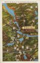
| Date: | 1931 |
|---|---|
| Description: | Text on front reads: "Map of the Dells of the Wisconsin River Region." On reverse: "All the world knows of the Wisconsin Dells. Many noted travelers have p... |
If you didn't find the material you searched for, our Library Reference Staff can help.
Call our reference desk at 608-264-6535 or email us at: