 Filter: Categories of Wisconsin Historical Images
Filter: Subject of Maps
Filter: Subject of water
Filter: Year of 1900-1999
Filter: Categories of Wisconsin Historical Images
Filter: Subject of Maps
Filter: Subject of water
Filter: Year of 1900-1999

| Date: | 1929 |
|---|---|
| Description: | This map shows the entire state of Wisconsin and Minnesota and portions of Illinois and Iowa. Counties, cities, highways, lakes, and rivers are labeled. Ro... |

| Date: | 1990 |
|---|---|
| Description: | This map, in addition to the Fort ground and buildings, shows owners of outbuildings, heights of buildings in stories, fences, roads, gardens, and cemetery... |

| Date: | 1937 |
|---|---|
| Description: | Map showing territory controlled by the Finches, a family of bandits who terrorized south central Wisconsin in the years prior to the Civil War. The map in... |

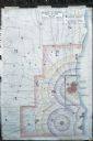
| Date: | 01 13 1937 |
|---|---|
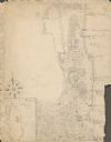
| Description: | Sketch map of Township 7 North, Range 9 East, created for the Land Economic Inventory (Bordner Survey). The map shows Picnic Point and the Lake Mendota sho... |

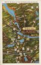
| Date: | 11 1964 |
|---|---|
| Description: | Fold-out map of the zoo inside a publication titled: "Henry Vilas Park Zoo: An Instructive Book on the Origin and Habits of Animals." Includes Lake Wingra,... |

| Date: | 1938 |
|---|---|
| Description: | Front cover of "At Home Abroad" brochure. |
| Date: | 1938 |
|---|---|
| Description: | Back cover of "At Home Abroad" brochure featuring the continent of Australia. |
| Date: | 1938 |
|---|---|
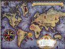
| Description: | Inside spread of "At Home Abroad" brochure. The title reads: "A World-wide Sales and Service Organization." Features a map of the continents of the world. ... |

| Date: | 1925 |
|---|---|
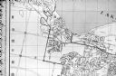
| Description: | Map of northern Africa with the border between Algeria and Tunisia drawn in red. Caption reads: "199A — (L61208) Map Series 2 The Eastern Barbary States." |
| Date: | 1929 |
|---|---|
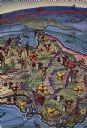
| Description: | An unsigned, hand-drawn map of properties owned by members of the Brumder family on the northwest shore of Pine Lake in 1929. Named Villa Henrietta, the pr... |
| Date: | 06 1960 |
|---|---|
| Description: | Photograph of street map of the Village of Shorewood Hills and Blackhawk Country Club. Lake Mendota is at the top of the map. |

| Date: | 1911 |
|---|---|
| Description: | Map of states in the United States, as well as inset maps of Russia, France, Germany and Sweden. At bottom right is a key for the map that includes: a numb... |
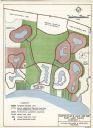
| Date: | 03 28 1964 |
|---|---|
| Description: | A master plan and land use map for East Lake Wales in Polk County, Florida showing where industrial sites, a shopping and civic center, golf course, marina... |
| Date: | 1960 |
|---|---|
| Description: | Map showing the probable blast radius of a 20 megaton bomb on Milwaukee. The map also shows existing hospitals in the area, including outside Milwaukee Cou... |
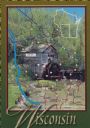
| Date: | 1988 |
|---|---|
| Description: | Text on front, at the foot: "Wisconsin." The color image of Hyde's Mill has an overlay of a map of the southwest corner of Wisconsin inside a red frame. Th... |
| Date: | 1931 |
|---|---|
| Description: | Text on front reads: "Map of the Dells of the Wisconsin River Region." On reverse: "All the world knows of the Wisconsin Dells. Many noted travelers have p... |

| Date: | 1962 |
|---|---|
| Description: | Map of the city of Nancy, France. The IH Branch and a warehouse are circled. |

| Date: | 1962 |
|---|---|
| Description: | Title reads: "Plan de Ris-Orangis, Seine et Oise." The office or factory is indicated by a black circle. |

| Date: | 1962 |
|---|---|
| Description: | Map of the location of the office or factory, which is indicated by a black circle. |

| Date: | 1962 |
|---|---|
| Description: | Map of the location of the office or factory, which is indicated by a black circle. |
If you didn't find the material you searched for, our Library Reference Staff can help.
Call our reference desk at 608-264-6535 or email us at: