 Filter: Categories of Wisconsin Historical Images
Filter: Subject of Maps
Filter: Subject of great lakes
Filter: Categories of Wisconsin Historical Images
Filter: Subject of Maps
Filter: Subject of great lakes

| Date: | 1926 |
|---|---|
| Description: | Pages 21 and 22 from the 1926 schedule are a map showing the routes of the Goodrich Transit Company, Great Lakes Transit Company, Detroit and Cleveland Lin... |

| Date: | 1930 |
|---|---|
| Description: | Page 8 of the 1930 schedule is a map of the routes of the Goodrich Steamship Lines in Lake Michigan and Lake Huron. |

| Date: | 1905 |
|---|---|
| Description: | Bird's-eye view of Manitowoc on the shores of Lake Michigan. A map of the northeastern part of the United States at the top indicates Manitowoc's location ... |

| Date: | |
|---|---|
| Description: | Sketch of the Fort at Michilimackinac (also called Mackinac) as it was under French rule. |
| Date: | |
|---|---|
| Description: | Carte-de-visite map of Wisconsin. Broken down into a grid, and includes some topography and Lake Michigan. The letters "M.C." have been written on top of t... |

| Date: | 1887 |
|---|---|
| Description: | A bird's-eye map of Menekaune, Menominee and Marinette. |
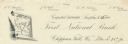
| Date: | |
|---|---|
| Description: | Numbered letterhead of the First National Bank, with a map of Wisconsin and a starred location marker for Chippewa Falls, a medallion, and a flowering stal... |

| Date: | 02 1823 |
|---|---|
| Description: | A map featuring the North American expedition from Pittsburgh to the Rocky Mountains led by Edwin James. |

| Date: | 1952 |
|---|---|
| Description: | Map of the barley-growing regions of North America, published by the Rahr Malting Company, Manitowoc, Wisconsin, 1952. |
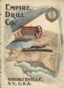
| Date: | 1900 |
|---|---|
| Description: | Catalog cover featuring an illustration of an Empire Drill on a map of the northeast United States. A railroad train is traveling east to west from Albany ... |
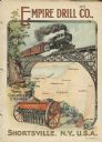
| Date: | 1901 |
|---|---|
| Description: | Catalog cover with the title: "The Three Greatest Empires," features an illustration of an Empire Drill in the foreground, and in the background a train tr... |

| Date: | 1937 |
|---|---|
| Description: | This map shows the major roads, cities, towns, lakes, and rivers of Wisconsin and some of the neighboring states. The front includes an add for Coca-Cola, ... |

| Date: | 1937 |
|---|---|
| Description: | This map shows the major cities, towns, highways, roads, lakes, and rivers of Wisconsin and some of the neighboring states. An index is included on the fro... |

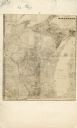
| Date: | 1881 |
|---|---|
| Description: | This map shows railroads, county boundaries, cities, towns, and waterways with relief shown by hachures. The prime meridians are: Greenwich and Washington.... |

| Date: | 1887 |
|---|---|
| Description: | This map shows railroads, county boundaries, cities, towns, and waterways with relief shown by hachures. The prime meridians are: Greenwich and Washington.... |

| Date: | 1710 |
|---|---|
| Description: | A seminal and fairly accurate map of the Great Lakes Region up to Baffin's Bay in Northern Canada. This is possibly the first printed map to locate Detroit... |

| Date: | 1696 |
|---|---|
| Description: | This sea chart and topographical map depicts the north east coast of Canada and North America, focusing on the Hudson Bay and Great Lakes regions. It shows... |

| Date: | 1685 |
|---|---|
| Description: | A detailed map of the western hemisphere showing cities, settlements, Native American land, rivers, lakes, mountains, the Great Lakes, and California as an... |

| Date: | 1766 |
|---|---|
| Description: | Map of the north western hemisphere using sinusoidal projection to show the curvature of the earth. It labels regions, cities, Native American land, island... |

| Date: | 1755 |
|---|---|
| Description: | Map of colonial America, showing the lands north of South Carolina and west of the Mississippi River. An inset map of the Carolinas and Georgia sits in the... |
If you didn't find the material you searched for, our Library Reference Staff can help.
Call our reference desk at 608-264-6535 or email us at: