Filter: Categories of Wisconsin Historical Images
Filter: Subject of Landforms
Filter: Year of 1800-1899
Filter: Year of 1850-1859
Filter: Categories of Wisconsin Historical Images
Filter: Subject of Landforms
Filter: Year of 1800-1899
Filter: Year of 1850-1859
| Date: | 1858 |
|---|---|
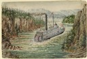
| Description: | In August 1858, Hölzlhuber traveled up the St. Croix River to Stillwater, Minnesota, on the steamship Winona. He noted the upper Mississippi's tribu... |

| Date: | 1855 |
|---|---|
| Description: | Part of George Harrison's "Map of the City of Madison," showing the development of the isthmus and the small size of the second Capitol (54' x 104') in com... |
| Date: | 1856 |
|---|---|
| Description: | At the beginning of his journey to America, Hölzlhuber passed through the English Channel and viewed the cliffs at Dover. "We passed Beachy Head, as this p... |

| Date: | 1856 |
|---|---|
| Description: | While passing through the English Channel in May 1856 Hölzlhuber viewed the Isle of Wight. "The island is located in the English Channel not far from Hamps... |
| Date: | 1858 |
|---|---|
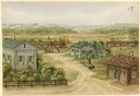
| Description: | Hölzlhuber located this farm at about three German miles from Stevens Point. The region's soil was quite fertile. A wooden dwelling house stood in the mids... |
| Date: | 1859 |
|---|---|
| Description: | Mr. Klaner, who had just come from Elberfeld to Canada in 1858, purchased this farm and worked it with his wife and children. Initially they were plagued b... |
| Date: | 1856 |
|---|---|
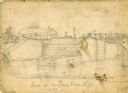
| Description: | An original illustration of the lock at Rexford Flats. |

| Date: | 1856 |
|---|---|
| Description: | Isthmus of Madison, including Lake Mendota, or Great Lake, and Lake Menona [sic]. |

| Date: | 1857 |
|---|---|
| Description: | A color-coded map of the Lake Superior region, including portions of Wisconsin, Minnesota and Michigan. |
| Date: | 08 1852 |
|---|---|
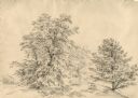
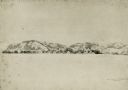
| Description: | Pencil drawing of Rattlesnake Bluff and the town of Arena from a distance across a plain. A row of buildings runs along the foot of the gently rolling hill... |

| Date: | 1852 |
|---|---|
| Description: | A hand-colored map showing portions of present-day Iron and Vilas counties north of the Manitowish River as part of the Upper Peninsula of Michigan. The Wi... |

| Date: | 1852 |
|---|---|
| Description: | Map shows Wisconsin counties by color and includes rivers, lakes and some cities. This information is also given for eastern Minnesota and northern Illinoi... |

| Date: | 1857 |
|---|---|
| Description: | This map shows section corners, quarter section corners, foundry, steam saw mill, steam grist mill, planning mill, court house, baptist church, congregatio... |

| Date: | 09 01 1856 |
|---|---|
| Description: | This map is pen-and-ink and shows farm lots, other lots of land sectioned by acres, bluffs, and a coulee. Also included are notations in pencil and blue in... |

| Date: | 1853 |
|---|---|
| Description: | A map of Wellfleet Harbor on Cape Cod Bay. |
If you didn't find the material you searched for, our Library Reference Staff can help.
Call our reference desk at 608-264-6535 or email us at: