 Filter: Categories of Wisconsin Historical Images
Filter: Subject of Landforms
Filter: Subject of sailing ships
Filter: Categories of Wisconsin Historical Images
Filter: Subject of Landforms
Filter: Subject of sailing ships

| Date: | 1908 |
|---|---|
| Description: | Colored map showing a panoramic view of Madison in great detail. The Wisconsin State Capitol is located at the center, with Lake Mendota in the background ... |
| Date: | 1832 |
|---|---|
| Description: | Camp of the Gros Ventres along the upper Missouri River, with white travelers passing by in a boat. |

| Date: | 1870 |
|---|---|
| Description: | Birds-eye drawing of Oconomowoc depicts street names and street layouts, houses, trees, Oconomowoc River, Fowler Lake, and La Belle Lake. A reference key a... |

| Date: | 02 26 1887 |
|---|---|
| Description: | Bird's-eye map of Ashland, and the Apostle Islands in Lake Superior. Caption reads: "Ashland and the Apostle Islands." |

| Date: | 1892 |
|---|---|
| Description: | Bird's-eye view of Chicago, with ships in the Lake Michigan harbor. |

| Date: | 1632 |
|---|---|
| Description: | The Wisconsin portion of Champlain's 1632 map, augmented since the previous one, for navigation according to the true Meridien, by Sieur de Champlain. The ... |
| Date: | 1856 |
|---|---|
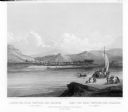
| Description: | At the beginning of his journey to America, Hölzlhuber passed through the English Channel and viewed the cliffs at Dover. "We passed Beachy Head, as this p... |

| Date: | 1856 |
|---|---|
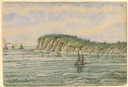
| Description: | While passing through the English Channel in May 1856 Hölzlhuber viewed the Isle of Wight. "The island is located in the English Channel not far from Hamps... |
| Date: | 1915 |
|---|---|
| Description: | View from shoreline over water towards a three-masted sailing vessel docked at Baileys Harbor pier. Houses and commercial buildings line the shore. |

| Date: | 1785 |
|---|---|
| Description: | Map of part of North America engraved and hand-colored (the light brown design is a superposition of the map and cartouche derived from the oxidation of th... |

| Date: | 1966 |
|---|---|
| Description: | A colored map depiction of Door County, Wisconsin, with pictorial highlights, titled: "Door County — Wisconsin's Air Conditioned Peninsula Playground." |
| Date: | 1905 |
|---|---|
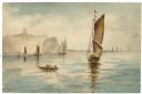
| Description: | Watercolor painting of boats and sailboats on Lake Mendota, looking towards Maple Bluff, perhaps from Governor's Island or Rocky Roost. |

| Date: | 1612 |
|---|---|
| Description: | Map of New France, the area that is now eastern Canada and north eastern United States, showing lakes, rivers, and landforms. The locations of several Nati... |
If you didn't find the material you searched for, our Library Reference Staff can help.
Call our reference desk at 608-264-6535 or email us at: