 Filter: Categories of Wisconsin Historical Images
Filter: Subject of Landforms
Filter: Subject of michigan, lake
Filter: Categories of Wisconsin Historical Images
Filter: Subject of Landforms
Filter: Subject of michigan, lake
| Date: | |
|---|---|
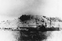
| Description: | The sidewheel passenger and freight, "Milwaukee," at Dewey Hill, Grand Haven, Michigan, at the Detroit, Grand Haven and Milwaukee Railway depot. |

| Date: | 1898 |
|---|---|
| Description: | Bird's-eye map, looking west from shoreline on Lake Michigan of Milwaukee to Golden Lake in Waukesha County, with Kenosha and Fox Point at bottom corners, ... |

| Date: | 1892 |
|---|---|
| Description: | Bird's-eye view of Chicago, with ships in the Lake Michigan harbor. |

| Date: | 1632 |
|---|---|
| Description: | The Wisconsin portion of Champlain's 1632 map, augmented since the previous one, for navigation according to the true Meridien, by Sieur de Champlain. The ... |

| Date: | 1941 |
|---|---|
| Description: | Official highway map of Wisconsin, "the playground of the Midwest," showing the state transportation network prior to World War II. |

| Date: | 1848 |
|---|---|
| Description: | Immigrant map. |

| Date: | 1670 |
|---|---|
| Description: | This map is in French and shows Lac Tracy ov Superieur (Lake Superior), Baye des Puans (Green Bay), and portions of Lac des Ilinois (Lake Michigan) and Lac... |

| Date: | 1776 |
|---|---|
| Description: | In French: "Partie Occidentale du Canada et septentrionale de la Louisiane avec une partie de la Pensilvanie." A map showing graticule and six European sca... |

| Date: | 1882 |
|---|---|
| Description: | This basic reference map of the state shows natural features, railroads, county seats, and political boundaries against the G.L.O. township and range grid.... |

| Date: | 1910 |
|---|---|
| Description: | Wisconsin Geological and Natural History Survey, by Lawrence Martin reproduced from a model of the state prepared by W.O. Hotchkiss and F.T. Thwaites and m... |

| Date: | 1868 |
|---|---|
| Description: | Showing the counties, towns and railroads. Partly colored. Scale: 1 inch = 20 miles. |

| Date: | 1916 |
|---|---|
| Description: | Southeastern Wisconsin which lies east of Whitewater and south of Port Washington. |

| Date: | |
|---|---|
| Description: | Plan of township no. 3 north, range no. 5 west of the 4th principal meridian. |

| Date: | 1950 |
|---|---|
| Description: | This map of east central Wisconsin around Lake Winnebago and the southern portion of Green Bay shows the moraines, drumlins, eskers, sand dunes, old beach ... |

| Date: | 1905 |
|---|---|
| Description: | A reproduction of the Wisconsin portion of Louis Hennepin's 1698 map showing the location of the Ho-Chunk Tribe, the Hurons, the Illinois as well as other ... |

| Date: | 1852 |
|---|---|
| Description: | A hand-colored map showing portions of present-day Iron and Vilas counties north of the Manitowish River as part of the Upper Peninsula of Michigan. The Wi... |

| Date: | 1852 |
|---|---|
| Description: | Map shows Wisconsin counties by color and includes rivers, lakes and some cities. This information is also given for eastern Minnesota and northern Illinoi... |

| Date: | 1837 |
|---|---|
| Description: | This map shows the townships, roads, trails, natural land forms, vegetation, mill sites and lead and copper deposits in the Wisconsin Territory at the time... |
| Date: | 1925 |
|---|---|
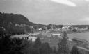
| Description: | Elevated view of Fish Creek from the east; the bluff rises on the left, the harbor is on the right. The cottage in the foreground with pergola and lattice ... |
If you didn't find the material you searched for, our Library Reference Staff can help.
Call our reference desk at 608-264-6535 or email us at:
