 Filter: Categories of Wisconsin Historical Images
Filter: Subject of Landforms
Filter: Subject of lakes
Filter: Categories of Wisconsin Historical Images
Filter: Subject of Landforms
Filter: Subject of lakes

| Date: | 1952 |
|---|---|
| Description: | Aerial view of a North Central Airlines DC-3 airplane flying over the Madison isthmus. Clearly visible are the Wisconsin State Capitol, the 1 West Wilson S... |

| Date: | 1940 |
|---|---|
| Description: | Aerial view looking east over the center of the city and the University of Wisconsin-Madison campus. |

| Date: | 1908 |
|---|---|
| Description: | Colored map showing a panoramic view of Madison in great detail. The Wisconsin State Capitol is located at the center, with Lake Mendota in the background ... |

| Date: | 1835 |
|---|---|
| Description: | Little Lake Butte Des Morts just north of Lake Winnebago where Governor Lewis Cass of Michigan, and Thomas McKenney, head of the Bureau of Indian Affairs (... |

| Date: | 1908 |
|---|---|
| Description: | A panoramic aerial view of the Isthmus taken from a kite. Lake Mendota is to the right in the background with Picnic Point jutting into the lake. The photo... |

| Date: | 05 09 1908 |
|---|---|
| Description: | Kite aerial panoramic photograph of the central business district. In the distance is Lake Mendota. The fire damaged Wisconsin State Capitol is in the cent... |

| Date: | 1870 |
|---|---|
| Description: | Bird's-eye map of Hudson, with insets of Court House and Public School. |

| Date: | 1885 |
|---|---|
| Description: | Bird's-eye map of Madison, State Capital of Wisconsin, County Seat of Dane County, with inset of the Wisconsin State Capitol. |

| Date: | 1891 |
|---|---|
| Description: | Bird's-eye view of Eau Claire. |
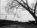
| Date: | 05 05 1931 |
|---|---|
| Description: | View across Lake Mendota towards Picnic Point, framed by a willow tree, and a rowboat pulled up on the shoreline. |

| Date: | 06 30 1926 |
|---|---|
| Description: | View across Observatory Drive, looking down towards the Van Hise dormitories: Adams, Tripp, and Carson Gulley Commons. Picnic Point is in the distance on L... |

| Date: | 12 1925 |
|---|---|
| Description: | Elevated view of the Van Hise Dormitories under construction: Adams, Tripp, Carson Gulley Commons, and a view of Picnic Point, at the University of Wiscons... |

| Date: | 1898 |
|---|---|
| Description: | Bird's-eye map, looking west from shoreline on Lake Michigan of Milwaukee to Golden Lake in Waukesha County, with Kenosha and Fox Point at bottom corners, ... |

| Date: | 1870 |
|---|---|
| Description: | Birds-eye drawing of Oconomowoc depicts street names and street layouts, houses, trees, Oconomowoc River, Fowler Lake, and La Belle Lake. A reference key a... |

| Date: | 1855 |
|---|---|
| Description: | Part of George Harrison's "Map of the City of Madison," showing the development of the isthmus and the small size of the second Capitol (54' x 104') in com... |

| Date: | 1896 |
|---|---|
| Description: | A portion of John B. Heim's map of the Water Works System of Madison showing the size of the third Wisconsin Capitol (228' x 226') in comparison with the C... |
| Date: | 1898 |
|---|---|
| Description: | Elevated view of Observatory Hill, Observatory Hall, the Agriculture Campus and Lake Mendota on the University of Wisconsin-Madison Campus. |

| Date: | 1945 |
|---|---|
| Description: | View of the lower campus of the University of Wisconsin-Madison includes Bascom Hill, Wisconsin Historical Society, Memorial Union and the Armory (Red Gym ... |

| Date: | 1923 |
|---|---|
| Description: | Aerial view of the Wisconsin Historical Society, Science Hall, and Bascom Hall on Bascom Hill on the University of Wisconsin-Madison campus. Lake Mendota i... |
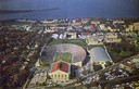
| Date: | 1963 |
|---|---|
| Description: | Aerial view of Camp Randall during a football game on the University of Wisconsin-Madison campus with Picnic Point in the background. |
If you didn't find the material you searched for, our Library Reference Staff can help.
Call our reference desk at 608-264-6535 or email us at: