 Filter: Categories of Wisconsin Historical Images
Filter: Subject of Land
Filter: Year of 1600-1699
Filter: Subject of persons
Filter: Categories of Wisconsin Historical Images
Filter: Subject of Land
Filter: Year of 1600-1699
Filter: Subject of persons
| Date: | 1655 |
|---|---|
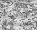
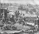
| Description: | Scene from the Laudonnière Expedition in South Carolina, ca. 1564. |
| Date: | 1655 |
|---|---|
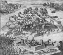
| Description: | Scene from Laudonnière Expedition in Florida, ca. 1567. |

| Date: | 1655 |
|---|---|
| Description: | Map from Drake Expedition, ca. 1585. |

| Date: | 1655 |
|---|---|
| Description: | Map from Drake Expedition in Florida, ca. 1585. |
| Date: | 1655 |
|---|---|
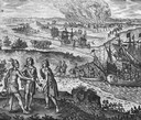
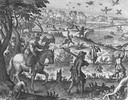
| Description: | Scene from Jamestown Settlement in Virginia, 1610. |
| Date: | 1655 |
|---|---|
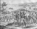
| Description: | Scene from Jamestown Settlement in which the brothers of Pocahontas visit her. |
| Date: | 1655 |
|---|---|
| Description: | Scene from near Jamestown Settlement in Virginia, ca. 1614. The Chickahominy tribe's proximity to Jamestown meant they had early contact with the English.... |
| Date: | 1655 |
|---|---|
| Description: | Scene from near Jamestown Settlement, ca. 1620. |

| Date: | 1632 |
|---|---|
| Description: | The Wisconsin portion of Champlain's 1632 map, augmented since the previous one, for navigation according to the true Meridien, by Sieur de Champlain. The ... |

| Date: | 1673 |
|---|---|
| Description: | P. Marquette en Joliet, gedan in't jaar 1673. |

| Date: | 1688 |
|---|---|
| Description: | This map includes vignettes of Amerindian life with text describing geography, culture, and exploration activity, written in French. The Great Lakes, river... |

| Date: | 1625 |
|---|---|
| Description: | An illustrated map of the world with captions in Latin. Illustrations include depictions of the seasons and the elements. |

| Date: | 1698 |
|---|---|
| Description: | An illustration of two men looking out at Niagara Falls. The Niagara Falls in Jean Louis Hennepin’s A new discovery of a vast country in America (London: M... |

| Date: | 1696 |
|---|---|
| Description: | Engraved and hand-colored map of Ethiopia, from Blaeu's General Atlas. Map title is framed by a man and a woman, both wearing head turbans, who are standin... |

| Date: | 1627 |
|---|---|
| Description: | Map of North and South America showing settlements, rivers, lakes, mountains, islands and regions of the western hemisphere. It includes an inset map of Gr... |

| Date: | 1630 |
|---|---|
| Description: | One of the few maps by Dutch cartographer Willem Blaeu depicting the Americas, this map shows regions, settlements, islands, mountains, forests, rivers, an... |

| Date: | 1690 |
|---|---|
| Description: | A mysterious mixture of mythology, ancient geography, and late 17th century knowledge of the American coastline. This map shows North and South America, bu... |

| Date: | 1676 |
|---|---|
| Description: | Detailed map of North and South America. Cities, towns, forests, and mountains are shown pictorially. Duval labels regions, islands, cities, lakes, and Nat... |

| Date: | 1685 |
|---|---|
| Description: | A detailed map of the western hemisphere showing cities, settlements, Native American land, rivers, lakes, mountains, the Great Lakes, and California as an... |

| Date: | 1636 |
|---|---|
| Description: | Map of North America, divided into regions, and showing some rivers, lakes, settlements, cities, mountains, and Native American land. Of the Great Lakes on... |
If you didn't find the material you searched for, our Library Reference Staff can help.
Call our reference desk at 608-264-6535 or email us at: