 Filter: Categories of Wisconsin Historical Images
Filter: Subject of Land
Filter: Subject of writing
Filter: Categories of Wisconsin Historical Images
Filter: Subject of Land
Filter: Subject of writing

| Date: | 1908 |
|---|---|
| Description: | Front and back of a postcard sent from Agnes to William (Bill) Quinney. The front features a print of the Cliffs of Dover in pastel tones while, on the ba... |

| Date: | 1863 |
|---|---|
| Description: | This map is a hand-colored, pen and ink, drawing by Ole R. Dahl of Co. B, 15 Wisconsin Infantry shows the battlefield at Stones River, depicting roads, str... |

| Date: | 10 19 1836 |
|---|---|
| Description: | This 1836 manuscript map shows the sections, windfalls, marshes, streams, prairies, acreages, and former mouth of the Pike River in what is now the eastern... |

| Date: | 08 17 1874 |
|---|---|
| Description: | This manuscript drawing provides a side elevation, plan, and perspective view for a proposed lock on the Fox River. |

| Date: | 1905 |
|---|---|
| Description: | This pictorial representation of part of Lake Winnebago and the Fox River in 1703, showing interactions between white beaver hunters and the Iroquois is ta... |

| Date: | 06 1837 |
|---|---|
| Description: | Pen-and-ink on paper. Shows riverside property west of the Milwaukee River. Inscribed by several early Milwaukee settlers, including Henry W. Cleveland, Cy... |

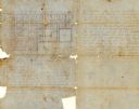
| Date: | 1848 |
|---|---|
| Description: | Pen-and-ink on paper. Includes certifications signed by "Geo R. Bluntz, District Survey of Grant Co. W.T." and Ben C. Eastman. |
| Date: | 08 1851 |
|---|---|
| Description: | Ink on paper. Includes explanation and a certification signed by Jacob Marty, Electa Marty, and a justice of the peace. Original map is very light and in f... |
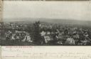
| Date: | |
|---|---|
| Description: | Photographic postcard of an elevated view of Baraboo from a hill, showing mainly dwellings. Bluffs are in the far background. Caption reads: "Baraboo, View... |
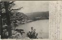
| Date: | 1906 |
|---|---|
| Description: | View from bluff of Devil's Lake. A road runs along the far shoreline. Caption reads: "Devil's Lake, Baraboo, Wis." |

| Date: | 1856 |
|---|---|
| Description: | This map is ink and pencil on paper and shows plat of the town, local streets, and blocks and lots by number. The map includes explanatory text. |
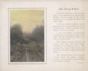
| Date: | 1920 |
|---|---|
| Description: | A hand-tinted photograph of a rutted, one lane country road is mounted with a printed border on a sheet of beige paper with a short essay printed alongside... |
| Date: | 1920 |
|---|---|
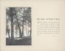
| Description: | A hand-tinted photograph of a scene along the wooded shore of Devil's Lake is mounted on a piece of beige paper. The scene features an old section of a woo... |
| Date: | 1920 |
|---|---|
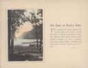
| Description: | A hand-tinted photograph of a tree-framed scene along the shore of Devil's Lake is mounted on a piece of beige paper. A large bluff dominates the backgroun... |

| Date: | 11 1836 |
|---|---|
| Description: | This map is pen-and-ink on paper and is a plat of a paper city on the Wisconsin River, in what is now the Town of Dekorra. The map shows lot and block numb... |

| Date: | 06 1845 |
|---|---|
| Description: | This map is pen-and-ink on paper and shows the numbers, dimensions, and acreages of lots, as well as survey monuments and streets. Also included is a certi... |

| Date: | 1776 |
|---|---|
| Description: | This was one of the first maps available for the general British populace featuring America during the Revolutionary War. It includes forts, cities, topogr... |

| Date: | 1769 |
|---|---|
| Description: | Double hemispherical map showing the continents, islands, countries, and a few major cities of the world. The routes of a few explorers are depicted and la... |

| Date: | 1780 |
|---|---|
| Description: | Map of North and South America, showing the boundaries of colonial territories, cities, settlements, rivers, lakes, and Native American land. Particular em... |

| Date: | 1747 |
|---|---|
| Description: | Map of America showing rivers, lakes, mountains, and regions, but primarily focusing on the French and Native American settlements along the Mississippi th... |
If you didn't find the material you searched for, our Library Reference Staff can help.
Call our reference desk at 608-264-6535 or email us at: