 Filter: Categories of Wisconsin Historical Images
Filter: Subject of Land
Filter: Subject of taverns (inns)
Filter: Categories of Wisconsin Historical Images
Filter: Subject of Land
Filter: Subject of taverns (inns)
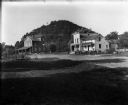
| Date: | 1909 |
|---|---|
| Description: | A mill, left, and a commercial building with attached residence stand in front of a wooded bluff. A woman crosses a small bridge near the mill. |
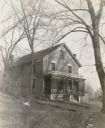
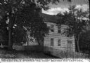
| Date: | 1914 |
|---|---|
| Description: | The Vermont House, a former tavern used as a residence. |

| Date: | 1930 |
|---|---|
| Description: | View up Main Street, with houses up on a hill on the left above a stone wall that runs along the sidewalk. On the right is a sign that reads: "Maiden R[ock... |
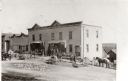
| Date: | 1910 |
|---|---|
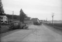
| Description: | Exterior view of the Strachota Brothers general store and saloon, including people and horses. Caption reads: "Strachota Bros. Gen Store & Saloon, St. Kili... |
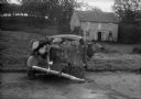
| Date: | 10 11 1944 |
|---|---|
| Description: | Wrecked car in front of Alma's Inn, 5068 Highway 12-13. Injured in the accident were five men en route to work at the Badger Ordnance Works at Baraboo. T... |
| Date: | 10 11 1944 |
|---|---|
| Description: | Scene of wrecked car and semi-trailer truck in front of Alma's Inn, 5068 Highway 12-13. Injured in the accident were five men en route to work at the Badge... |
| Date: | |
|---|---|
| Description: | The Mother Chick Tavern, where Nathan Hale, widely considered America's first spy during the American Revolutionary War, stopped the night before his captu... |

| Date: | |
|---|---|
| Description: | A view of the inn, casino, and other structures at The Oakbirch Inn and Casino taken from a tree-lined road. A man sits in the passenger side of a car park... |
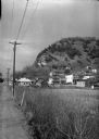
| Date: | 1936 |
|---|---|
| Description: | View along side of road across a field of a village on the Mississippi bluffs, with many houses and telephone lines visible. |

| Date: | |
|---|---|
| Description: | View featuring stores and dwellings built into hillsides. Castle Rock appears on the right side of a road. Opposite the landform, the Castle Rock Lodging... |

| Date: | |
|---|---|
| Description: | View of First Avenue, the main street in town. Stores, restaurants, and lodging houses stand on either side of the street. Snow-covered mountains rise in t... |

| Date: | 1934 |
|---|---|
| Description: | View down hill of a tavern, with signs advertising "Budweiser" and "Beer," on the shores of Clam Lake. There are numerous outbuildings and two automobiles ... |
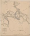
| Date: | 1864 |
|---|---|
| Description: | This map depicts the battlefield at Todd's Tavern, Va., the site of a battle on May 7-8, 1864. Depicted are roads, houses, drainage, vegetation and troop p... |

| Date: | 1930 |
|---|---|
| Description: | Pen and ink map on paper of Wisconsin and northern Illinois showing stagecoach routes (marked in red) that traveled between Lake Michigan and the Mississip... |

| Date: | 1975 |
|---|---|
| Description: | "Main (Milwaukee) Street. Six taverns were in business in the span of one block!" |

| Date: | 1858 |
|---|---|
| Description: | An ink on paper map of Milwaukee County and the eastern portion of Waukesha County that shows the townships of Oak Creek, Franklin, Greenfield, Wauwatosa, ... |

| Date: | 1870 |
|---|---|
| Description: | This 1870 map of Brown County, Wisconsin, shows the township and range grid, towns, sections, cities, villages and post offices, land ownership, roads, rai... |

| Date: | 1941 |
|---|---|
| Description: | This 1941 map covers Washburn County, Wisconsin, as well as western Sawyer, eastern Burnett, and northeastern Polk counties. It shows the locations of tour... |
| Date: | |
|---|---|
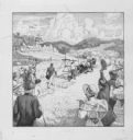
| Description: | "Testing of First Reaper at Steele's Tavern." Second version illustrating occasion. |

| Date: | 1915 |
|---|---|
| Description: | Copy of chromolithograph of the testing of the first reaping machine at Steele's Tavern, W. Virginia." The scene includes racist depictions of enslaved Afr... |
If you didn't find the material you searched for, our Library Reference Staff can help.
Call our reference desk at 608-264-6535 or email us at: