Filter: Categories of Wisconsin Historical Images
Filter: Subject of Land
Filter: Subject of sailing ships
Filter: Categories of Wisconsin Historical Images
Filter: Subject of Land
Filter: Subject of sailing ships

| Date: | 1908 |
|---|---|
| Description: | Colored map showing a panoramic view of Madison in great detail. The Wisconsin State Capitol is located at the center, with Lake Mendota in the background ... |
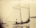
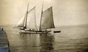
| Date: | 1902 |
|---|---|
| Description: | Ole Christinson, Dick Hanson, Fred Hanson, and Herman Johnson, Sr., onboard sailboat "Louis Moe" along the shore of Sand Island. |
| Date: | |
|---|---|
| Description: | Two men standing in wooden rowboat along shore of Madeline Island. There are sailboats in the background. Behind them is a large rock just off the shoreli... |
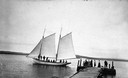
| Date: | 1900 |
|---|---|
| Description: | Sailboat Lizzie W. at the Mission Dock. Captain Daniel Russell Angus, in the white sleeves, is at the tiller. The boat was named after Elizabeth Woo... |
| Date: | 1900 |
|---|---|
| Description: | Group of people on sailboat "Alpha" at dock on Madeline Island. Captain Daniel Angus is at the tiller. |
| Date: | 1832 |
|---|---|
| Description: | Camp of the Gros Ventres along the upper Missouri River, with white travelers passing by in a boat. |

| Date: | 1885 |
|---|---|
| Description: | Bird's-eye map of Oconomowoc. |

| Date: | 1870 |
|---|---|
| Description: | Bird's-eye view of the city of Manitowoc with a population of 5,168 inhabitants as it appears in 1870, the year the village was granted a city charter by t... |

| Date: | 1870 |
|---|---|
| Description: | Birds-eye drawing of Oconomowoc depicts street names and street layouts, houses, trees, Oconomowoc River, Fowler Lake, and La Belle Lake. A reference key a... |

| Date: | 1879 |
|---|---|
| Description: | Bird's-eye map of Two Rivers. |

| Date: | 02 26 1887 |
|---|---|
| Description: | Bird's-eye map of Ashland, and the Apostle Islands in Lake Superior. Caption reads: "Ashland and the Apostle Islands." |

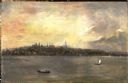
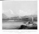
| Date: | 1858 |
|---|---|
| Description: | Elevated view from bluff looking down on city, with Lake Michigan in background. Detailed foreground with two boys playing with a grounded kite, while a ma... |

| Date: | 1655 |
|---|---|
| Description: | Map from Drake Expedition, ca. 1585. |

| Date: | 1655 |
|---|---|
| Description: | Map from Drake Expedition in Florida, ca. 1585. |

| Date: | 1892 |
|---|---|
| Description: | Bird's-eye view of Chicago, with ships in the Lake Michigan harbor. |
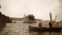
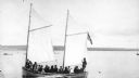
| Date: | 1910 |
|---|---|
| Description: | Gaff-rigged schooner the "Lizzie W." on Lake Superior just off from the mission dock on Madeline Island. |
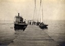
| Date: | 1910 |
|---|---|
| Description: | Steamboat "Skater" and two sailboats at end of the mission dock on Madeline Island. |

| Date: | 1632 |
|---|---|
| Description: | The Wisconsin portion of Champlain's 1632 map, augmented since the previous one, for navigation according to the true Meridien, by Sieur de Champlain. The ... |
If you didn't find the material you searched for, our Library Reference Staff can help.
Call our reference desk at 608-264-6535 or email us at: