 Filter: Categories of Wisconsin Historical Images
Filter: Subject of Land
Filter: Subject of rural areas
Filter: Subject of intellectual life
Filter: Categories of Wisconsin Historical Images
Filter: Subject of Land
Filter: Subject of rural areas
Filter: Subject of intellectual life

| Date: | 1870 |
|---|---|
| Description: | Bird's-eye view of the city of Manitowoc with a population of 5,168 inhabitants as it appears in 1870, the year the village was granted a city charter by t... |

| Date: | 1961 |
|---|---|
| Description: | Aerial view of a small settlement in the mountains, Luang Prabang vicinity, Laos. A narrow dirt road winds across the terrain and some buildings and an air... |

| Date: | |
|---|---|
| Description: | Letterhead of Madison Mobile Homes, with a three-quarter view of a mobile home parked in a clearing near a wooded area on a shoreline, with the slogan "Liv... |

| Date: | 1790 |
|---|---|
| Description: | This map of the north eastern states shows roads, rivers, lakes, waterfalls, mountains, cities, forts, mills, the Oneida Reservation, and "New York Donatio... |

| Date: | 1770 |
|---|---|
| Description: | The south west sheet of a four sheet map of Virginia, showing the counties, mountains, rivers, court houses, a few cities, and mills. A few Plantations ar... |

| Date: | 1776 |
|---|---|
| Description: | Map of New Jersey and New York, showing cities, forts, roads, counties, townships, land grants, rivers, lakes and several topographical features. Much of t... |

| Date: | 1780 |
|---|---|
| Description: | This map shows the townships, parishes, cities, towns, plantations, lakes, rivers, swamps, and roads near the coast of South Carolina and Georgia. Emphasis... |
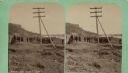
| Date: | 04 18 1888 |
|---|---|
| Description: | Stereograph of fireplace ruins on the site of an old French fort, possibly built by Nicholas Perrot. There is an electric pole behind the fireplace and a g... |

| Date: | 1950 |
|---|---|
| Description: | Aerial view of contour farming surrounding multiple farms and woods. |
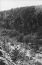
| Date: | 1950 |
|---|---|
| Description: | Text on front reads: "The Old Mill Stream in the Narrows at Rock Springs, Wis." A road and the Narrows Creek run next to each other in an elevated view of ... |
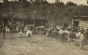
| Date: | 1910 |
|---|---|
| Description: | Text on front reads: "Prizewinners, Rusk Co. Wis. Fair." Slightly elevated view of cattle lined up with their owners during a competition at the County Fai... |
If you didn't find the material you searched for, our Library Reference Staff can help.
Call our reference desk at 608-264-6535 or email us at: