 Filter: Categories of Wisconsin Historical Images
Filter: Subject of Land
Filter: County of Dane
Filter: Subject of human settlements
Filter: Categories of Wisconsin Historical Images
Filter: Subject of Land
Filter: County of Dane
Filter: Subject of human settlements
| Date: | 1960 |
|---|---|
| Description: | Elevated view looking east from Lincoln Terrace on Bascom Hill on the University of Wisconsin-Madison campus. The Lincoln Monument is in the foreground and... |

| Date: | 1873 |
|---|---|
| Description: | Main Street, with its dirt, ruts, cows (and presumably manure), but wide enough for easy hitching of wagons and teams. |

| Date: | 1862 |
|---|---|
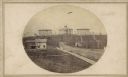
| Description: | Camp Randall looking southwest. In April 1861, Governor Alexander Randall asked that the State Agricultural Society fairgrounds be converted into a militar... |
| Date: | 1865 |
|---|---|
| Description: | University of Wisconsin-Madison campus showing the first three buildings on campus, South Hall (left), University Hall [Bascom Hall] (center), and North Ha... |
| Date: | 1873 |
|---|---|
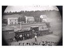
| Description: | Elevated view of several men, some of whom may be railroad workers, posing in front of a Minnesota and St. Paul wood-burning engine at a train crossing. Th... |

| Date: | 1952 |
|---|---|
| Description: | Aerial view of a North Central Airlines DC-3 airplane flying over the Madison isthmus. Clearly visible are the Wisconsin State Capitol, the 1 West Wilson S... |

| Date: | 1898 |
|---|---|
| Description: | University Heights from the Chemistry Building on University Avenue. View includes the University of Wisconsin-Madison football field, on the former site o... |
| Date: | 1906 |
|---|---|
| Description: | Elevated view of Camp Randall Field from the top of Bascom Hall, with University Heights in the background. A crowd is in the stands at the stadium, and a ... |

| Date: | 1940 |
|---|---|
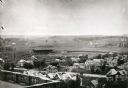
| Description: | Aerial view looking east over the center of the city and the University of Wisconsin-Madison campus. |

| Date: | 1893 |
|---|---|
| Description: | Back of painting reads: "Madison in June 1837 after photo taken by E.E. Bailey" and "Peck's cabin by Dengel." The Eben Peck cabin was the first house built... |

| Date: | |
|---|---|
| Description: | The Eben Peck cabin was the first house built in Madison. |

| Date: | 1908 |
|---|---|
| Description: | Colored map showing a panoramic view of Madison in great detail. The Wisconsin State Capitol is located at the center, with Lake Mendota in the background ... |

| Date: | 08 28 1970 |
|---|---|
| Description: | An aerial view of West Towne Shopping Center (now West Towne Mall) at Mineral Point and Gammon Roads. |
| Date: | 1945 |
|---|---|
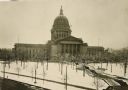
| Description: | Elevated view of the Wisconsin State Capitol. The Belmont Hotel is behind the capitol on the left, and beyond is Lake Mendota. |
| Date: | 1861 |
|---|---|
| Description: | Soldiers in formation at Camp Randall during winter. The season [there appears to be snow on the ground] and the tents indicate that this image was made in... |

| Date: | 1908 |
|---|---|
| Description: | A panoramic aerial view of the Isthmus taken from a kite. Lake Mendota is to the right in the background with Picnic Point jutting into the lake. The photo... |

| Date: | 06 07 1954 |
|---|---|
| Description: | Aerial view of the Midvale neighborhood under construction showing the intersection of Midvale and Tokay Boulevards near the southwestern city limits of Ma... |
| Date: | 1930 |
|---|---|
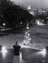
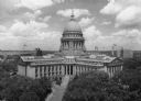
| Description: | Elevated view of the west wing of the Wisconsin State Capitol building. A view of the fourth capitol with snow flocked trees and snow-covered lawn and side... |

| Date: | 1851 |
|---|---|
| Description: | Plat map of the Town of Madison (Township 7N, Range 9E), from Volume 4, Federal Survey Plat Books. |
If you didn't find the material you searched for, our Library Reference Staff can help.
Call our reference desk at 608-264-6535 or email us at:
