 Filter: Categories of Wisconsin Historical Images
Filter: Subject of Lakes
Filter: Year of 1800-1899
Filter: Year of 1850-1859
Filter: Categories of Wisconsin Historical Images
Filter: Subject of Lakes
Filter: Year of 1800-1899
Filter: Year of 1850-1859

| Date: | 1855 |
|---|---|
| Description: | Bird's-eye view of Madison. "Taken from the Water Cure, South Side of Lake Monona, 1855." |

| Date: | 1856 |
|---|---|
| Description: | This map show the surveyed southern part of state and includes "profile of the Milwaukee and Mississippi Rail Road." Counties are shown in pink, green, blu... |

| Date: | 1850 |
|---|---|
| Description: | Elevated view of the Lake Superior shoreline, with terraces leading to the beach. A canoe is on the shoreline. |

| Date: | 1850 |
|---|---|
| Description: | Pastoral scene depicting a small bay on the Island of St. Ignace in Lake Superior with canoes on the rocky beach, two men conversing on a blanket in the fo... |

| Date: | 1851 |
|---|---|
| Description: | Plat map of the Town of Madison (Township 7N, Range 9E), from Volume 4, Federal Survey Plat Books. |

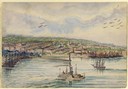
| Date: | 1856 |
|---|---|
| Description: | View looking west from Lake Michigan with several steam ships and sailing vessels in harbor. There is a lighthouse to left of center, along shoreline. |

| Date: | 1852 |
|---|---|
| Description: | Pencil drawing of Madison landscape as seen from University Hill. The main street in the center is State Street, and the building with Greek columns in the... |

| Date: | 1852 |
|---|---|
| Description: | Pencil drawing of view overlooking Madison. The sketch looks down North Hamilton Street from the capitol. Rutted, irregular streets and frame houses mark ... |
| Date: | 1851 |
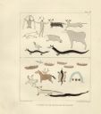
|---|---|
| Description: | Pictographs on Lake Superior and Carp River, Mich. Six rows of animals, canoes, birds, human figures, and other symbols. |

| Date: | 1857 |
|---|---|
| Description: | Bird's-eye view of Madison over rooftop and across lake with sailboats and steamers. A group of people are standing on a viewing platform on the roof in th... |

| Date: | 1855 |
|---|---|
| Description: | Part of George Harrison's "Map of the City of Madison," showing the development of the isthmus and the small size of the second Capitol (54' x 104') in com... |
| Date: | 1859 |
|---|---|
| Description: | South Pinckney Street as photographed by Fuller from the Wisconsin State Capitol roof. In the center are several wooden structures dating from Madison's e... |
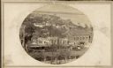
| Date: | 1857 |
|---|---|
| Description: | A distant, elevated view of the city of Milwaukee and its shoreline. During the hot summer months, Hölzlhuber, took excursions on the water, many times bri... |

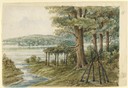
| Date: | 1856 |
|---|---|
| Description: | The Ludemann's [also spelled Lueddemann] farm had been cultivated since the early 1850s by Mr. Ludemann, "a very pleasant Saxon with his very pleasant wife... |
| Date: | 1858 |
|---|---|
| Description: | Hölzlhuber's first extensive excursion in Wisconsin was a walking tour from Madison to Prairie du Sac along the Wisconsin River. He lost his way along Lake... |
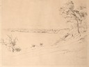
| Date: | 08 1852 |
|---|---|
| Description: | Pencil drawing of a lake shoreline. A few trees frame the arc of the shore and steamboats are visible along the distant shore. |

| Date: | 08 1852 |
|---|---|
| Description: | Pencil drawing of Milwaukee Harbor with large sailboats on the water. In the minimalist depiction the sandy shoreline with short plant growth sweeps aroun... |
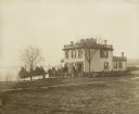
| Date: | 1855 |
|---|---|
| Description: | Early view of the house built by Madison's first mayor, Jairus C. Fairchild, at 302 South Wisconsin Avenue (renamed Monona Avenue in 1877) at West Wilson S... |

| Date: | 1857 |
|---|---|
| Description: | Quarter section of a map of the city of Fond du Lac featuring an illustration of the Lewis House. |

| Date: | 1853 |
|---|---|
| Description: | Farwell's Mill on the Yahara River at Lake Mendota. |
If you didn't find the material you searched for, our Library Reference Staff can help.
Call our reference desk at 608-264-6535 or email us at: