 Filter: Categories of Wisconsin Historical Images
Filter: Subject of Lakes
Filter: Year of 1800-1899
Filter: Subject of political science
Filter: Categories of Wisconsin Historical Images
Filter: Subject of Lakes
Filter: Year of 1800-1899
Filter: Subject of political science
| Date: | 1879 |
|---|---|
| Description: | Norwegian Sunday School Picnic at Mendota steamboat landing. Small lake steamer "Mendota" could reach speeds of up to 18 mph. The barge "Uncle Sam" was 75f... |

| Date: | 1884 |
|---|---|
| Description: | A sign for Fauerbach's Brewery depicting a young woman and the brewery. |

| Date: | 1835 |
|---|---|
| Description: | Little Lake Butte Des Morts just north of Lake Winnebago where Governor Lewis Cass of Michigan, and Thomas McKenney, head of the Bureau of Indian Affairs (... |

| Date: | 1875 |
|---|---|
| Description: | Elevated view of people, elegantly dressed, posing on a pier, with a steamboat and rowboats docked on it on Devil's Lake. An American flag is on the steamb... |

| Date: | 1876 |
|---|---|
| Description: | "View of the Capitol, with all the Flags" one of four "Different Views of Parades in the Streets" identified in Dahl's 1877 "Catalogue of Stereoscopic View... |

| Date: | 07 1875 |
|---|---|
| Description: | Chicago Traveling Club encamped at McBride's Point at Maple Bluff on Lake Mendota near Madison. An African American sits at the left foreground with pans ... |

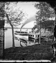
| Date: | 1878 |
|---|---|
| Description: | People seated in a small steamboat tied at a pier on a lake. A flag flies from the bow and there is a two-story frame house on the shore. This photograph m... |

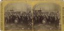
| Date: | 1878 |
|---|---|
| Description: | Group portrait of a large group of men, women and children, at a lake shore, possibly Maple Bluff on Lake Mendota near Madison. The Norwegian flag suggests... |
| Date: | 05 17 1870 |
|---|---|
| Description: | A large group, mainly men, are gathered behind the "Lake City Cornet Band" who are in uniform near a lake shore, possibly Lake Monona. The card was marked ... |

| Date: | 1862 |
|---|---|
| Description: | Lithography of C. Van Benthuysen. |

| Date: | 1855 |
|---|---|
| Description: | Map reads "Our Country" which is accompanied by a sailor with a flag to the left and workers rejoicing under the Constitution and Laws to the right. Across... |

| Date: | 1889 |
|---|---|
| Description: | From a map published by Angell and Hastreither, the drawing depicts the Tonyawatha Spring Hotel grounds on Lake Monona. The hotel, located in Blooming Grov... |
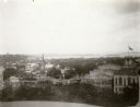
| Date: | 1896 |
|---|---|
| Description: | View from the Wisconsin State Capitol dome looking west towards Bascom Hill. Mifflin street with City Hall and the Fuller Opera House are in the foreground... |
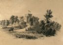
| Date: | 1863 |
|---|---|
| Description: | A view overlooking the grounds towards the Benjamin Walker Castle, 1862-1893 in the 900 block of East Gorham Street, and its surrounding property. A man is... |
| Date: | 1893 |
|---|---|
| Description: | View of the Columbian Exposition grounds from Lake Michigan. |

| Date: | 1883 |
|---|---|
| Description: | A hand-colored map of Wisconsin showing the nine congressional districts, it also shows the counties, cities, railroads, rivers, and lakes in the state. |

| Date: | 1845 |
|---|---|
| Description: | Wisconsin was considered part of Michigan Territory until 1836, a year before Michigan entered statehood. Drawn three years before Wisconsin entered stateh... |

| Date: | 1898 |
|---|---|
| Description: | A hand-colored, cloth mounted map of Wisconsin showing the state’s congressional districts. The map also shows the counties, cities, towns, villages, river... |

| Date: | 1889 |
|---|---|
| Description: | Shows city limits, railroads, mills, schools, cemeteries, dams, parks, lumber yards, log canals, log reservoir, Chippewa River, Eau Claire River, and Half ... |

| Date: | 09 04 1885 |
|---|---|
| Description: | Exterior and interior bill of fare from The Chequamegon, with views on the back of rock formations, waterfalls, a spot illustration of a train going over a... |
If you didn't find the material you searched for, our Library Reference Staff can help.
Call our reference desk at 608-264-6535 or email us at: