 Filter: Categories of Wisconsin Historical Images
Filter: Subject of Lakes
Filter: Year of 1800-1899
Filter: Subject of cities and towns
Filter: Categories of Wisconsin Historical Images
Filter: Subject of Lakes
Filter: Year of 1800-1899
Filter: Subject of cities and towns

| Date: | 1870 |
|---|---|
| Description: | Bird's-eye map of Madison. The Lakeside House resort is in the foreground, which burned in 1877, in what is now Olin Park. |

| Date: | 1868 |
|---|---|
| Description: | Bird's-eye map of Manitowoc, with four insets. Manitowoc County. |

| Date: | 1898 |
|---|---|
| Description: | Bird's-eye map, looking west from shoreline on Lake Michigan of Milwaukee to Golden Lake in Waukesha County, with Kenosha and Fox Point at bottom corners, ... |

| Date: | 1870 |
|---|---|
| Description: | Birds-eye drawing of Oconomowoc depicts street names and street layouts, houses, trees, Oconomowoc River, Fowler Lake, and La Belle Lake. A reference key a... |

| Date: | 1893 |
|---|---|
| Description: | Bird's-eye map of Superior. Looking from the point, with Superior Bay on left, St. Louis Bay on right, below St. Louis River. |

| Date: | 1870 |
|---|---|
| Description: | Bird's-eye view of Whitewater, with insets. |

| Date: | 1890 |
|---|---|
| Description: | Colored bird's-eye map of Oconomowoc and the Lake Region, Waukesha County. Looking North from Government Hill. Location key below image identifies 24 Hotel... |
| Date: | 1882 |
|---|---|
| Description: | Bird's-eye view of Milwaukee looking south down 8th Street from Schlitz's Park. |

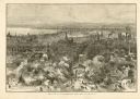
| Date: | 1857 |
|---|---|
| Description: | Bird's-eye view of Madison over rooftop and across lake with sailboats and steamers. A group of people are standing on a viewing platform on the roof in th... |
| Date: | 1873 |
|---|---|
| Description: | Elevated view of South Pinckney Street from the Wisconsin State Capitol, with East Washington Avenue to the left and Lake Monona on the distant right. The ... |
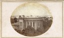
| Date: | 1861 |
|---|---|
| Description: | East (King Street) wing of the third Wisconsin State Capitol and the south wall of the Territorial Capitol (at the left) taken from the roof of the buildin... |
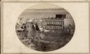
| Date: | 1860 |
|---|---|
| Description: | Intersection of King and East Main streets photographed by John S. Fuller from the Wisconsin State Capitol roof, about 1860-1863. In the foreground two st... |

| Date: | 1855 |
|---|---|
| Description: | Part of George Harrison's "Map of the City of Madison," showing the development of the isthmus and the small size of the second Capitol (54' x 104') in com... |

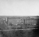
| Date: | 1896 |
|---|---|
| Description: | A portion of John B. Heim's map of the Water Works System of Madison showing the size of the third Wisconsin Capitol (228' x 226') in comparison with the C... |

| Date: | 1886 |
|---|---|
| Description: | Bird's-eye map of Baraboo with inset of Devil's Lake, the south and east sides of the commercial square, the First National Bank, and the Warren House hote... |
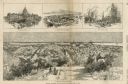
| Date: | 03 30 1889 |
|---|---|
| Description: | Bird's-eye view from Bascom Hill of Madison, with vignettes of the Wisconsin State Capitol, Lake Monona, and the Capitol Park. |
If you didn't find the material you searched for, our Library Reference Staff can help.
Call our reference desk at 608-264-6535 or email us at:


