Filter: Categories of Wisconsin Historical Images
Filter: Subject of Lakes
Filter: Year of 1800-1899
Filter: Subject of cities and towns
Filter: Categories of Wisconsin Historical Images
Filter: Subject of Lakes
Filter: Year of 1800-1899
Filter: Subject of cities and towns
| Date: | 1860 |
|---|---|
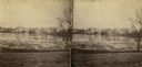
| Description: | Stereograph of the Townsend House boathouse across a lake. |
| Date: | 1860 |
|---|---|
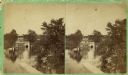
| Description: | Stereograph of Townsend House. Image includes people sitting on porch, grounds, boat dock. |
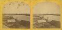
| Date: | 1871 |
|---|---|
| Description: | Stereograph of a sawmill area and Lake Winnebago in the foreground. The square building with the "cupola" was the Revere House. A manuscript notation, very... |
| Date: | 1870 |
|---|---|
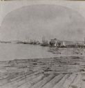
| Description: | Stereograph of an elevated view of the lumbering industry on the Fox River. Lake Winnebago is in the background. |

| Date: | 1868 |
|---|---|
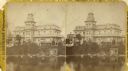
| Description: | Stereograph of an elevated view of the Vilas House hotel, East Main Street at Monona Avenue. |

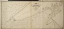
| Date: | 1824 |
|---|---|
| Description: | Drawn and engraved by Sidney Hall. Published by Longman, Hurst, Rees, Orme, Brown & Green. Scale: 1:200. Partly colored. This is probably the second Europe... |

| Date: | 1837 |
|---|---|
| Description: | Photographic print of an amateur painting, probably representing the "first house in Madison, Wisconsin." The Peck Cabin, one of the many free variations o... |
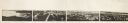
| Date: | 1870 |
|---|---|
| Description: | Panoramic view of Madison, taken from the roof of South Hall. This reduced copy was made from original negatives by E.C. Nielson. Labels for both Lake Mend... |
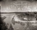
| Date: | 05 19 1895 |
|---|---|
| Description: | A view from the bluff of group of men on the dredge bank of Buffalo Lake. |

| Date: | 1852 |
|---|---|
| Description: | Map reads: "The State of Wisconsin- compiled from the latest authorities". In addition, there is a scale which is six miles for every inch, and a profile o... |

| Date: | 1855 |
|---|---|
| Description: | Map reads "Our Country" which is accompanied by a sailor with a flag to the left and workers rejoicing under the Constitution and Laws to the right. Across... |

| Date: | 1854 |
|---|---|
| Description: | Map reads, "Map of Wisconsin". The map includes the counties, an inset of the city of Milwaukee, total population of each county and of the state. The scal... |

| Date: | 1842 |
|---|---|
| Description: | Map reads: "Wisconsin". The map depicts the counties as of 1842 and the various areas of Indian settlements. The scale is twenty miles for every inch. |

| Date: | 1864 |
|---|---|
| Description: | Map reads: "Johnson's Wisconsin and Michigan". There is a decorative border, a scale of which ten miles is approximately one inch and individual counties d... |

| Date: | 1861 |
|---|---|
| Description: | A map of Wisconsin showing cities, counties, major roads, railroads, and bodies of water. Includes an inset of the vicinity of Milwaukee. |

| Date: | 1849 |
|---|---|
| Description: | Geological map of the mineral region around Lake Superior, including portions of Michigan, Wisconsin, Iowa and Illinois. |

| Date: | 1858 |
|---|---|
| Description: | Map of the Lake Superior region showing the railroad and steamboat connections. |
| Date: | 1856 |
|---|---|
| Description: | Map of a portion of Douglas and La Pointe counties situated on Lake Superior. |

| Date: | 1857 |
|---|---|
| Description: | A color-coded map of the Lake Superior region, including portions of Wisconsin, Minnesota and Michigan. |
If you didn't find the material you searched for, our Library Reference Staff can help.
Call our reference desk at 608-264-6535 or email us at: