 Filter: Categories of Wisconsin Historical Images
Filter: Subject of Lakes
Filter: Subject of writing
Filter: Categories of Wisconsin Historical Images
Filter: Subject of Lakes
Filter: Subject of writing
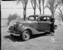
| Date: | 05 22 1933 |
|---|---|
| Description: | Janette Serrec, University of Wisconsin graduate, lecturer and writer on the "Fine Art of Successful Living," standing beside a Pontiac automobile she drov... |

| Date: | 1905 |
|---|---|
| Description: | This pictorial representation of part of Lake Winnebago and the Fox River in 1703, showing interactions between white beaver hunters and the Iroquois is ta... |
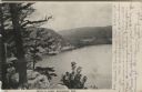
| Date: | 1906 |
|---|---|
| Description: | View from bluff of Devil's Lake. A road runs along the far shoreline. Caption reads: "Devil's Lake, Baraboo, Wis." |
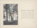
| Date: | 1920 |
|---|---|
| Description: | A hand-tinted photograph of a scene along the wooded shore of Devil's Lake is mounted on a piece of beige paper. The scene features an old section of a woo... |
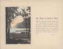
| Date: | 1920 |
|---|---|
| Description: | A hand-tinted photograph of a tree-framed scene along the shore of Devil's Lake is mounted on a piece of beige paper. A large bluff dominates the backgroun... |

| Date: | 1776 |
|---|---|
| Description: | This was one of the first maps available for the general British populace featuring America during the Revolutionary War. It includes forts, cities, topogr... |

| Date: | 1780 |
|---|---|
| Description: | Map of North and South America, showing the boundaries of colonial territories, cities, settlements, rivers, lakes, and Native American land. Particular em... |

| Date: | 1747 |
|---|---|
| Description: | Map of America showing rivers, lakes, mountains, and regions, but primarily focusing on the French and Native American settlements along the Mississippi th... |

| Date: | 1758 |
|---|---|
| Description: | Map showing lakes, rivers, cities, Native American land, and the boundaries of French and English claims in America and Canada north of New York. A title c... |

| Date: | |
|---|---|
| Description: | View down slope towards several men posing at the shoreline while taking part in a lakeside gathering. Many of them are sitting on the grass or on boats dr... |
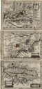
| Date: | 1675 |
|---|---|
| Description: | Three maps found within John Speed's atlas A Prospect of the Most Famous Parts of the World along with the corresponding text. The first map shows V... |

| Date: | 02 1977 |
|---|---|
| Description: | A man is kneeling on the ice and snow at Potter's Lake. He is running a machine that is testing the oxygen levels in the water, while recording the results... |
If you didn't find the material you searched for, our Library Reference Staff can help.
Call our reference desk at 608-264-6535 or email us at: