 Filter: Categories of Wisconsin Historical Images
Filter: Subject of Lakes
Filter: Subject of trails
Filter: Categories of Wisconsin Historical Images
Filter: Subject of Lakes
Filter: Subject of trails
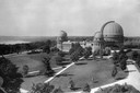
| Date: | 1935 |
|---|---|
| Description: | Elevated exterior view of Yerkes Observatory. Geneva Lake is in the background, left. Roads and sidewalks cross the sweeping, well tended lawns. The desi... |

| Date: | 1936 |
|---|---|
| Description: | This map is red and black ink on tracing cloth and is oriented with north to the upper left. This hand-drawn map shows a central portion of the military ro... |
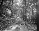
| Date: | 06 27 1931 |
|---|---|
| Description: | Path, "main street," through the woods at the University of Wisconsin Tent Colony. Also known as Camp Gallistella on the south shore of Lake Mendota, west ... |
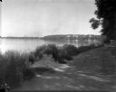
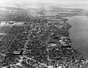
| Date: | 1926 |
|---|---|
| Description: | Lake Mendota, including Fraternity Row and east side shoreline, taken from the lake path on University Bay Drive. |
| Date: | 1926 |
|---|---|
| Description: | View of Adams, Tripp and Van Hise Halls. All are residence halls on the University of Wisconsin campus with Picnic Point and Lake Mendota in the backgroun... |

| Date: | 1945 |
|---|---|
| Description: | View of the lower campus of the University of Wisconsin-Madison includes Bascom Hill, Wisconsin Historical Society, Memorial Union and the Armory (Red Gym ... |

| Date: | 1945 |
|---|---|
| Description: | Aerial view of Bascom Hill, Bascom Hall, Wisconsin Historical Society on the University of Wisconsin Madison campus with Lake Mendota on the right. |
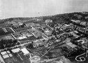
| Date: | 1923 |
|---|---|
| Description: | Aerial view of the University of Wisconsin campus shows from west to east the Agricultural Hall, Observatory Hall and the Wisconsin Historical Society with... |

| Date: | 1926 |
|---|---|
| Description: | Originally titled 'Recent Aeroplane View of University Campus', the view of the Wisconsin Historical Society, the Red Gym, Science Hall and Bascom Hall wit... |

| Date: | 1923 |
|---|---|
| Description: | Aerial view of the Wisconsin Historical Society, Science Hall, and Bascom Hall on Bascom Hill on the University of Wisconsin-Madison campus. Lake Mendota i... |
| Date: | 1946 |
|---|---|
| Description: | Aerial view of the University of Wisconsin campus with Lake Mendota on the right. |

| Date: | 1908 |
|---|---|
| Description: | Drawing of the general design for future construction development at the University of Wisconsin with the Barn, Sheep Barn, Horse Barn, House, Power House,... |

| Date: | 1908 |
|---|---|
| Description: | General design for future construction development of the University of Madison campus with the general view of the campus by the Architectural commission. |

| Date: | 1910 |
|---|---|
| Description: | Elevated view of Bascom Hill on the University of Wisconsin-Madison campus from the south between the Chemistry Building and Lake Mendota. |
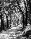
| Date: | 1930 |
|---|---|
| Description: | View of the Lakeshore Path in Bascom Woods by Lake Mendota, later dedicated the Howard M. Temin Lake Shore Path on the University of Wisconsin-Madison camp... |

| Date: | 1956 |
|---|---|
| Description: | Aerial view of lower University of Wisconsin-Madison campus with demolition of buildings on both sides of the Armory-Gymnasium to make space for future pla... |

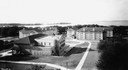
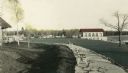
| Date: | 1929 |
|---|---|
| Description: | View of the College of Agriculture on the University of Wisconsin Madison campus as seen from the tower of the First Congressional Church. |
| Date: | |
|---|---|
| Description: | Hand-colored view of the Thordarson estate including the boathouse and a stone-paved path with benches. |

| Date: | 1907 |
|---|---|
| Description: | Elevated view looking northeast from the chimney of the Power Plant on University Avenue. The Chemistry Building is in the foreground, and Bascom Hall and ... |
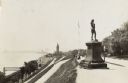
| Date: | 1915 |
|---|---|
| Description: | Located in Juneau Park, the statue is on the right, on the edge of a steep hill. The hillside is lined with paths, and ends next to several railroad track... |
If you didn't find the material you searched for, our Library Reference Staff can help.
Call our reference desk at 608-264-6535 or email us at: