 Filter: Categories of Wisconsin Historical Images
Filter: Subject of Lakes
Filter: Subject of persons
Filter: Type of Map or Atlas
Filter: Categories of Wisconsin Historical Images
Filter: Subject of Lakes
Filter: Subject of persons
Filter: Type of Map or Atlas

| Date: | 1870 |
|---|---|
| Description: | Bird's-eye view of Whitewater, with insets. |

| Date: | 1949 |
|---|---|
| Description: | Color bird's-eye map of the University of Wisconsin-Madison as it was midcentury, with two co-eds, several photographs of campus landmarks around edges, an... |

| Date: | 1632 |
|---|---|
| Description: | The Wisconsin portion of Champlain's 1632 map, augmented since the previous one, for navigation according to the true Meridien, by Sieur de Champlain. The ... |

| Date: | 1848 |
|---|---|
| Description: | Immigrant map. |

| Date: | 1855 |
|---|---|
| Description: | Map reads "Our Country" which is accompanied by a sailor with a flag to the left and workers rejoicing under the Constitution and Laws to the right. Across... |

| Date: | 1688 |
|---|---|
| Description: | This map includes vignettes of Amerindian life with text describing geography, culture, and exploration activity, written in French. The Great Lakes, river... |

| Date: | 1930 |
|---|---|
| Description: | Pictorial map of Glacier National Park, Montana and Waterton Lakes National Park, Alberta. Illustrated by Joe Scheurle, it depicts white people, American ... |

| Date: | 1930 |
|---|---|
| Description: | The back of the pictorial map titled Recreational Map of Glacier National Park, Montana: Waterton Lakes National Park, Alberta. 14 panels of text and photo... |

| Date: | 1909 |
|---|---|
| Description: | A brochure with a map showing the North-Western Railway lines from northern Illinois, starting at Chicago, to southeastern Wisconsin, stopping at Sheboygan... |
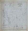
| Date: | 1918 |
|---|---|
| Description: | This map is ink on tracing paper showing all the counties of Wisconsin. The upper right hand corner contains a legend for distinguishing Wisconsin counties... |

| Date: | 1979 |
|---|---|
| Description: | A map of Southern Wisconsin and northern Illinois showing the areas inhabited by the Ho-Chuck, formerly known as the Winnebago. Some of the location names ... |

| Date: | 1835 |
|---|---|
| Description: | This hand-colored map shows the area from Michigan west to the Missouri River and Lake Winnipeg, and includes expedition routes of Stephen H. Long and Henr... |

| Date: | 1936 |
|---|---|
| Description: | This pictorial tourist map from the Wisconsin Conservation Commission depicts vacation activities and identifies tourist destinations throughout the state.... |
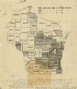
| Date: | 1905 |
|---|---|
| Description: | A map of showing the population density of foreign-born Scandinavians in Wisconsin based information from the 1905 census. The map also shows the county bo... |
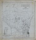
| Date: | |
|---|---|
| Description: | A map indicating the population density of German-born people in Wisconsin based on the 1905 census. The map shows the county boundaries throughout the sta... |

| Date: | 1946 |
|---|---|
| Description: | A map showing the roads, railroads, towns, cities and villages, streams and lakes, airports, schools, churches, cemeteries, and golf courses in Kenosha Cou... |

| Date: | 1970 |
|---|---|
| Description: | A map of parks of Kewaunee County, Wisconsin, showing the fishing spots, lakes and parks in the area, it also provides a location map of the area. On the ... |

| Date: | |
|---|---|
| Description: | This 1907 map of Outagamie County, Wisconsin, shows the township and range grid, towns, sections, cities and villages, railroads, wagon roads, churches, sc... |

| Date: | 1910 |
|---|---|
| Description: | This early 20th century map shows "choice lake properties owned by Rusk Farm Company, Eau Claire, Wis." on Potato Lake in the Town of Rusk, Rusk County, Wi... |

| Date: | 1960 |
|---|---|
| Description: | This mid-20th century tourist brochure for Bayfield County, Wisconsin, includes a map of the county showing towns, cities and villages, highways and roads,... |
If you didn't find the material you searched for, our Library Reference Staff can help.
Call our reference desk at 608-264-6535 or email us at: