 Filter: Categories of Wisconsin Historical Images
Filter: Subject of Lakes
Filter: Subject of courthouses
Filter: Categories of Wisconsin Historical Images
Filter: Subject of Lakes
Filter: Subject of courthouses
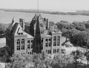
| Date: | 1958 |
|---|---|
| Description: | Elevated view of the Dane County Courthouse as it is being razed. Much of it is still intact in this image. Lake Monona and Monona Bay are in the distance. |

| Date: | 1870 |
|---|---|
| Description: | Bird's-eye map of Hudson, with insets of Court House and Public School. |

| Date: | 1852 |
|---|---|
| Description: | Pencil drawing of Madison landscape as seen from University Hill. The main street in the center is State Street, and the building with Greek columns in the... |

| Date: | 1868 |
|---|---|
| Description: | Bird's-eye map of Portage, with insets of the Court House and the Public School. |
| Date: | 1861 |
|---|---|
| Description: | East (King Street) wing of the third Wisconsin State Capitol and the south wall of the Territorial Capitol (at the left) taken from the roof of the buildin... |
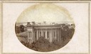
| Date: | 1862 |
|---|---|
| Description: | John S. Fuller took this image of the third Wisconsin State Capitol (the second in Madison), from Governor Farwell's Octagon House, probably early in 1862.... |
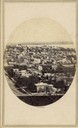
| Date: | |
|---|---|
| Description: | Elevated view toward the County Courthouse from University Hall (now Bascom Hall) of the University of Wisconsin-Madison. The County Courthouse is in the u... |

| Date: | 1859 |
|---|---|
| Description: | Map featuring various views of buildings and scenes from Sauk County. |
| Date: | 1885 |
|---|---|
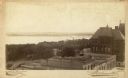
| Description: | View towards Lake Monona, with the Dane County Courthouse on the right. Text at bottom reads: "Curtiss Madison Wis." |

| Date: | 1883 |
|---|---|
| Description: | Caption on reverse side of stereograph reads, "Governmental buildings, Wisconsin Conservatory of Music and Hospital over Lake Mendota-looking from Capitol ... |
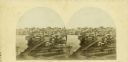
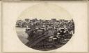
| Date: | 1862 |
|---|---|
| Description: | The third Wisconsin State Capitol (the second in Madison), from Governor Farwell's Octagon House, probably early in 1862. Also visible in the downtown are ... |

| Date: | 1883 |
|---|---|
| Description: | Caption on reverse side of stereograph reads: "Governmental buildings, Wisconsin Conservatory of Music and Hospital over Lake Mendota-looking from Capitol ... |

| Date: | 02 09 1954 |
|---|---|
| Description: | Elevated view of North Pinckney street on the Capitol Square in Madison as seen from the Wisconsin State Capitol Building. |

| Date: | 1859 |
|---|---|
| Description: | This 1859 map of Washington County, Wisconsin, shows the township and range grid, towns, sections, landownership and acreages, cities and villages, roads, ... |

| Date: | 1947 |
|---|---|
| Description: | Shows lot and block numbers, 28 points of interest in the upper left that correspond to numbers on the map, and landownership with acreages. "Erickson Brot... |

| Date: | 1800 |
|---|---|
| Description: | Shows plat of town, land ownership by name, local streets, courthouses, churches, hotels, mills, railroads, railroad stations, lakes, and rivers. Includes ... |

| Date: | 1990 |
|---|---|
| Description: | This map includes two insets: Plat of New Holstein village and Village of Chilton. The map also includes a table of statistics showing the assessed value o... |
If you didn't find the material you searched for, our Library Reference Staff can help.
Call our reference desk at 608-264-6535 or email us at: