 Filter: Categories of Wisconsin Historical Images
Filter: Subject of Lakes
Filter: Subject of corn
Filter: Categories of Wisconsin Historical Images
Filter: Subject of Lakes
Filter: Subject of corn
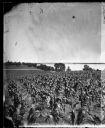
| Date: | 1875 |
|---|---|
| Description: | View from Southeast shore of Lake Monona across a cornfield, perhaps on the farm of Thomas Williamson. |

| Date: | 1906 |
|---|---|
| Description: | A hand-colored commercial map of Wisconsin and portions of eastern Minnesota, Iowa, northern Illinois, and the Michigan’s Upper Peninsula. The map shows ra... |

| Date: | 1923 |
|---|---|
| Description: | This map includes an explanation that reads: "This chart shows the movement of corn on the Great Lakes, St. Lawrence River, and New York State Barge Canal ... |
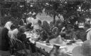
| Date: | 1897 |
|---|---|
| Description: | The Meinhardt family assembled for a picnic in their garden. A river or lake is in the far background. The table is set with china and flatware. Among the ... |

| Date: | 1900 |
|---|---|
| Description: | Three photographs taped together form a panoramic view from the top of the wooden tower built by George Brumder in 1892. The tower was built on Brumder's s... |

| Date: | 1922 |
|---|---|
| Description: | A group of Holts and Garrisons are roasting corn around a smoking campfire on the Island, with Archibald Lake in the background. W.A. Holt is on the far le... |
If you didn't find the material you searched for, our Library Reference Staff can help.
Call our reference desk at 608-264-6535 or email us at: