 Filter: Categories of Wisconsin Historical Images
Filter: Subject of Lakes
Filter: Subject of canals
Filter: Categories of Wisconsin Historical Images
Filter: Subject of Lakes
Filter: Subject of canals

| Date: | 1837 |
|---|---|
| Description: | Map of the proposed route of the Milwaukee and Rock River Canal. |
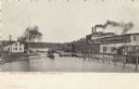
| Date: | |
|---|---|
| Description: | View of the Inter Lake Pulp Mill. Smoke is billowing out of the mill's smokestack. A boat is crossing the canal between two lakes. Caption reads: "Inter La... |

| Date: | 1853 |
|---|---|
| Description: | Wisconsin counties by color and shows railroads, common roads, canals, the state capital, county towns, townships, villages, and post offices, |

| Date: | 1854 |
|---|---|
| Description: | Map of the whole state Wisconsin includes an inset of the vicinity of Milwaukee, which shows the boundaries for Lisbon, Menomonee, Pewaukee, Brookfield, Wa... |

| Date: | 1857 |
|---|---|
| Description: | This detailed map was drawn nearly a decade after Wisconsin entered statehood. It depicts the entire state, northern Illinois and part of the upper peninsu... |

| Date: | 1839 |
|---|---|
| Description: | This map shows the township and section grid, lakes, rivers, swamps, prairies, roads, and proposed canals in the area of Wisconsin south of Lake Winnebago ... |

| Date: | 1839 |
|---|---|
| Description: | Wisconsin was considered part of Michigan Territory until 1836, a year before Michigan entered statehood. Drawn in 1839, this map shows the state of Michig... |

| Date: | 1840 |
|---|---|
| Description: | This hand-colored map shows the township and section grid in southeastern Wisconsin, covering the area west to Sugar River and Four Lakes region and north ... |

| Date: | 1844 |
|---|---|
| Description: | Wisconsin was considered part of Michigan Territory until 1836, a year before Michigan entered statehood. Drawn four years before Wisconsin entered stateho... |

| Date: | 1845 |
|---|---|
| Description: | Wisconsin was considered part of Michigan Territory until 1836, a year before Michigan entered statehood. Drawn three years before Wisconsin entered stateh... |

| Date: | 1939 |
|---|---|
| Description: | This nine-part map from the U.S. Bureau of Public Roads identifies federal and state highways in Wisconsin by pavement type. County, forest, park, and publ... |

| Date: | 1944 |
|---|---|
| Description: | This nine-part map from the U.S. Bureau of Public Roads identifies federal and state highways in Wisconsin by pavement type. County, forest, park, and publ... |

| Date: | 1866 |
|---|---|
| Description: | This map shows the railroads both completed and under construction in southern Wisconsin, Iowa, Illinois, and Missouri. Railroad terminals, junctions, and ... |

| Date: | 1906 |
|---|---|
| Description: | A hand-colored commercial map of Wisconsin and portions of eastern Minnesota, Iowa, northern Illinois, and the Michigan’s Upper Peninsula. The map shows ra... |

| Date: | 1837 |
|---|---|
| Description: | A pen and ink on tracing paper, hand-drawn and colored map the proposed route of the Milwaukee and Rock River Canal, ranging from the Rock River in the wes... |

| Date: | |
|---|---|
| Description: | This 19th century manuscript map of the Town of Oconomoc, Waukesha County, Wisconsin, is drawn on a printed township grid. It shows landownership and lakes... |
| Date: | 1931 |
|---|---|
| Description: | Prepared by Robert K. Boyd for his article "Up and down the Chippewa River" which appeared in the March 1931 issue of the Wisconsin Magazine of History, th... |

| Date: | 1918 |
|---|---|
| Description: | This 1918 map of Chippewa County, Wisconsin, shows the township and range grid, towns, sections, cities and villages, rural residences, churches, schools, ... |

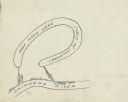
| Date: | 1881 |
|---|---|
| Description: | Ink, watercolor, and pencil on paper. Top of the map reads: "NORTHERN OUTLET MENASHA MEANDER LINES Scale 132ft 1 INCH Var S.E. Survey Completed Spet. 23 18... |
If you didn't find the material you searched for, our Library Reference Staff can help.
Call our reference desk at 608-264-6535 or email us at:
