 Filter: Categories of Wisconsin Historical Images
Filter: Subject of Islands
Filter: Subject of warships
Filter: Categories of Wisconsin Historical Images
Filter: Subject of Islands
Filter: Subject of warships

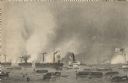
| Date: | 1862 |
|---|---|
| Description: | An image from a sketchbook of "The Gunboats at No. 10 — Eve of Arrival before the I'sld". The drawing appears to be from the deck of a ship showing several... |
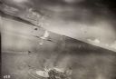
| Date: | 10 22 1943 |
|---|---|
| Description: | View across water of Mushu Island in the distance. There is a ship in the foreground, an airplane above, and the appearance of explosions in the water. |
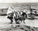
| Date: | 1945 |
|---|---|
| Description: | Three marines dressed in uniform, carrying packs and holding guns, pull an ammunition cart through the water towards the beach at Iwo Jima. Military boats ... |
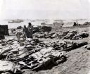
| Date: | 1945 |
|---|---|
| Description: | Marines, killed in action, lie on stretchers covered with ponchos on the beach at Iwo Jima. Four marines attend to the dead. Tents, military boats, and an ... |
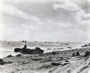
| Date: | 02 19 1945 |
|---|---|
| Description: | Marines on the beach and military boats, including an LSM 242, in the water at Iwo Jima. |
| Date: | |
|---|---|
| Description: | Etching of the "Attack upon Roanoke Island" by troops landing from naval vessels, after a painting by Chappel. |

| Date: | 1740 |
|---|---|
| Description: | Engraved and hand-colored map of the Iberian peninsula as a theater of war during the War of the Spanish Succession (1701-1714). The map is dedicated to Ki... |

| Date: | 10 1776 |
|---|---|
| Description: | Broadside map showing the British invasion of New York city in August and September of 1776. The map shows important cities, forts, roads, hills, mountains... |

| Date: | 02 1777 |
|---|---|
| Description: | Map depicting the campaigns of October and November 1776, in Manhattan, Westchester, and part of New Jersey, published only a few months after the conclusi... |

| Date: | 03 1777 |
|---|---|
| Description: | Map showing the British and Hessian attack on Fort Washington in November of 1776. The movements and fortifications of the British and Hessian troops appea... |
If you didn't find the material you searched for, our Library Reference Staff can help.
Call our reference desk at 608-264-6535 or email us at: