 Filter: Categories of Wisconsin Historical Images
Filter: Subject of Islands
Filter: Subject of transportation
Filter: Categories of Wisconsin Historical Images
Filter: Subject of Islands
Filter: Subject of transportation
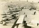
| Date: | 1912 |
|---|---|
| Description: | Photo opportunity day at the Glenn Curtiss School of Aviation on North Island in San Diego Harbor. The man in the lower left corner is thought to be Glenn ... |

| Date: | 05 1912 |
|---|---|
| Description: | The 1912 class at the Glenn Curtiss Aviation School on North Island, near San Diego. Milwaukee's John Kaminski (in white shirt and tie) is second from the ... |
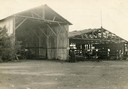
| Date: | 1912 |
|---|---|
| Description: | Hangars of the Curtiss Aviation School and the San Diego Aero Club on North Island in San Diego Harbor. Glenn Curtiss himself is thought to be the individu... |
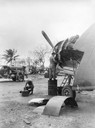
| Date: | 03 1945 |
|---|---|
| Description: | TAG operations on Falalop Island in the Pacific. This image is one of many taken by Milwaukee photographer Dickey Chapelle during the latter stages of the ... |

| Date: | 1870 |
|---|---|
| Description: | Bird's-eye map of Prairie du Sac. |
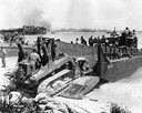
| Date: | 1944 |
|---|---|
| Description: | U.S. Marines using an International TD-9 diesel TracTracTor (crawler tractor) with a Bucyrus Erie shovel on an LCM (Landing Craft, Materiel) at Roi during ... |

| Date: | 1886 |
|---|---|
| Description: | Bird's-eye map of Washburn on Lake Superior. There is an inset of Washburn, Chequamagon and the Apostle Islands. |

| Date: | 1875 |
|---|---|
| Description: | Bird's-eye map of Black River Falls, looking southwest. |

| Date: | 1874 |
|---|---|
| Description: | Bird's-eye map of Chippewa Falls. |

| Date: | 1872 |
|---|---|
| Description: | Birds-eye drawing of Eau Claire depicts street names and street locations, houses, trees, bridges, piers, canals, railroads, and the Chippewa and Eau Clair... |

| Date: | 1870 |
|---|---|
| Description: | Birds-eye drawing of Oconomowoc depicts street names and street layouts, houses, trees, Oconomowoc River, Fowler Lake, and La Belle Lake. A reference key a... |

| Date: | 1883 |
|---|---|
| Description: | Bird's-eye map of Prairie du Sac, Wisconsin with an inset of Clifton. |

| Date: | 1883 |
|---|---|
| Description: | Bird's-eye map of Sauk City. |

| Date: | 1891 |
|---|---|
| Description: | Bird's-eye map of Stevens Point, looking east, with an inset of the Water Works. Wisconsin River in foreground with fifty-three business locations identifi... |

| Date: | 1879 |
|---|---|
| Description: | Bird's-eye map of Two Rivers. |

| Date: | 1910 |
|---|---|
| Description: | Bird's-eye view looking east, with Washburn Harbor at center and Chequamegon Bay in Lake Superior covering most of the upper image. Streets with buildings... |

| Date: | 1879 |
|---|---|
| Description: | This map is a bird's-eye view of Wausau, the County Seat of Marathon County. The map features an index of points of interest. |

| Date: | 1890 |
|---|---|
| Description: | Colored bird's-eye map of Oconomowoc and the Lake Region, Waukesha County. Looking North from Government Hill. Location key below image identifies 24 Hotel... |

| Date: | 02 26 1887 |
|---|---|
| Description: | Bird's-eye map of Ashland, and the Apostle Islands in Lake Superior. Caption reads: "Ashland and the Apostle Islands." |
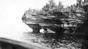
| Date: | |
|---|---|
| Description: | Devils Island on Lake Superior, outermost of the Apostle Islands group. There appears to be the edge of a boat in the foreground. |
If you didn't find the material you searched for, our Library Reference Staff can help.
Call our reference desk at 608-264-6535 or email us at: