 Filter: Categories of Wisconsin Historical Images
Filter: Subject of Islands
Filter: Subject of social issues
Filter: Categories of Wisconsin Historical Images
Filter: Subject of Islands
Filter: Subject of social issues
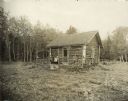
| Date: | 1914 |
|---|---|
| Description: | Log cabin known as the "haunted house" on Rock Island, remodeled by Chester Thordarson. There are three people sitting on the porch. |
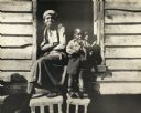
| Date: | |
|---|---|
| Description: | An African American woman with two children on the porch of a house on Johns Island. |
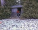
| Date: | 08 23 1964 |
|---|---|
| Description: | Lloyd Lehman stands in the open doorway of his small cabin on Washington Island. This cabin is one of a number of former summer camp buildings. |

| Date: | 1783 |
|---|---|
| Description: | This map is hand-colored and shows the boundaries of British, Spanish, and the newly recognized American claims, as well as the fishing rights granted to F... |

| Date: | 1780 |
|---|---|
| Description: | This map shows the townships, parishes, cities, towns, plantations, lakes, rivers, swamps, and roads near the coast of South Carolina and Georgia. Emphasis... |

| Date: | 1755 |
|---|---|
| Description: | Map of Virginia and parts of Maryland, North Carolina, and New Jersey. It shows borders, boundary lines, some Native American land, counties, cities, towns... |
If you didn't find the material you searched for, our Library Reference Staff can help.
Call our reference desk at 608-264-6535 or email us at: