 Filter: Categories of Wisconsin Historical Images
Filter: Subject of Islands
Filter: Subject of sailing ships
Filter: Categories of Wisconsin Historical Images
Filter: Subject of Islands
Filter: Subject of sailing ships
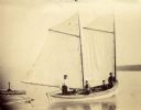
| Date: | 1902 |
|---|---|
| Description: | Ole Christinson, Dick Hanson, Fred Hanson, and Herman Johnson, Sr., onboard sailboat "Louis Moe" along the shore of Sand Island. |
| Date: | |
|---|---|
| Description: | Two men standing in wooden rowboat along shore of Madeline Island. There are sailboats in the background. Behind them is a large rock just off the shoreli... |
| Date: | 1900 |
|---|---|
| Description: | Sailboat Lizzie W. at the Mission Dock. Captain Daniel Russell Angus, in the white sleeves, is at the tiller. The boat was named after Elizabeth Woo... |
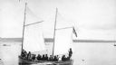
| Date: | 1900 |
|---|---|
| Description: | Group of people on sailboat "Alpha" at dock on Madeline Island. Captain Daniel Angus is at the tiller. |

| Date: | 1870 |
|---|---|
| Description: | Birds-eye drawing of Oconomowoc depicts street names and street layouts, houses, trees, Oconomowoc River, Fowler Lake, and La Belle Lake. A reference key a... |

| Date: | 1879 |
|---|---|
| Description: | Bird's-eye map of Two Rivers. |

| Date: | 02 26 1887 |
|---|---|
| Description: | Bird's-eye map of Ashland, and the Apostle Islands in Lake Superior. Caption reads: "Ashland and the Apostle Islands." |
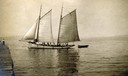
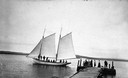
| Date: | 1910 |
|---|---|
| Description: | Gaff-rigged schooner the "Lizzie W." on Lake Superior just off from the mission dock on Madeline Island. |
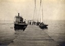
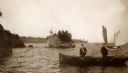
| Date: | 1910 |
|---|---|
| Description: | Steamboat "Skater" and two sailboats at end of the mission dock on Madeline Island. |

| Date: | 1856 |
|---|---|
| Description: | While passing through the English Channel in May 1856 Hölzlhuber viewed the Isle of Wight. "The island is located in the English Channel not far from Hamps... |

| Date: | 1829 |
|---|---|
| Description: | Hand-colored lithograph of Fort Armstrong, based on a drawing by Henry Lewis. Includes boats on the Mississippi River. |

| Date: | 07 21 1925 |
|---|---|
| Description: | Dinner menu from the Hotel St. Catherine, with a color postcard at the top, meant to be detached and mailed, with a view of the hotel against a backdrop of... |

| Date: | 1712 |
|---|---|
| Description: | Engraved double-hemispherical world map by Moll, included in his atlas The world described, or, A new and correct sett of maps: shewing the kingdoms and st... |

| Date: | 1785 |
|---|---|
| Description: | Map of part of North America engraved and hand-colored (the light brown design is a superposition of the map and cartouche derived from the oxidation of th... |

| Date: | |
|---|---|
| Description: | Elevated view of Green Bay from Ephraim. There is an island in the bay. Caption reads: "Lake View from Scandinavian Peasant Craft Shop, Ephraim, Wis." |

| Date: | 1900 |
|---|---|
| Description: | Three photographs taped together form a panoramic view from the top of the wooden tower built by George Brumder in 1892. The tower was built on Brumder's s... |
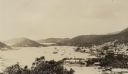
| Date: | 03 1913 |
|---|---|
| Description: | Elevated view of the harbor at Charlotte Amalie, St. Thomas. Sailing vessels of various sizes are moored in the harbor. There are islands in the background... |
If you didn't find the material you searched for, our Library Reference Staff can help.
Call our reference desk at 608-264-6535 or email us at: