 Filter: Categories of Wisconsin Historical Images
Filter: Subject of Islands
Filter: Subject of rural areas
Filter: Categories of Wisconsin Historical Images
Filter: Subject of Islands
Filter: Subject of rural areas

| Date: | 1780 |
|---|---|
| Description: | This map shows the townships, parishes, cities, towns, plantations, lakes, rivers, swamps, and roads near the coast of South Carolina and Georgia. Emphasis... |

| Date: | 1793 |
|---|---|
| Description: | Detailed topographical map of the Ohio River between Clarkville and Louisville. It shows plots of farmland, forest, islands, garden plots, houses, Fort Fe... |

| Date: | 1900 |
|---|---|
| Description: | Three photographs taped together form a panoramic view from the top of the wooden tower built by George Brumder in 1892. The tower was built on Brumder's s... |

| Date: | 1956 |
|---|---|
| Description: | Fresh snow on the wooded banks of the Fox River. |
| Date: | 1932 |
|---|---|
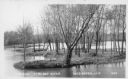
| Description: | Text on front reads: "Island Baraboo River Reedsburg, Wis." View of a tree and grass covered island on the Baraboo River. |
| Date: | 06 10 1952 |
|---|---|
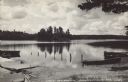
| Description: | Text on front reads: "Lake Thompson, Rhinelander, Wis." View of a wooded island from a boat landing on Lake Thompson. Rowboats are pulled up onto the shore... |

| Date: | 09 14 1922 |
|---|---|
| Description: | Text on front reads: "On the Wisconsin." Wooded islands on the Wisconsin River as seen from the shore. The opposite shoreline is in the background. The pow... |
| Date: | 07 12 1910 |
|---|---|
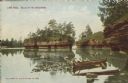
| Description: | Text on front reads: "Lone Rock, Dells of the Wisconsin." A view of Lone Rock from below, with a canoe on the right-hand side, near the shore. |

| Date: | 08 25 1911 |
|---|---|
| Description: | Text on front reads: "Down River from Round Bluff, Prairie Du Sac, Wis." A view of the Wisconsin River with buildings and a road along the left shoreline. ... |
| Date: | 1940 |
|---|---|
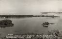
| Description: | Text on front reads: "Sawyer Harbor and Cabot's Point from Tower, Potowatomi State Park, Door County, Wis." Elevated view across Sawyer Harbor towards Stur... |

| Date: | 09 04 1913 |
|---|---|
| Description: | Text on front reads: "'Castle Rock,' 2nd Peak, Trempealeau, Wis., on-the-Mississippi." Elevated view towards a rock formation on the Mississippi River. Isl... |
If you didn't find the material you searched for, our Library Reference Staff can help.
Call our reference desk at 608-264-6535 or email us at: