 Filter: Categories of Wisconsin Historical Images
Filter: Subject of Islands
Filter: Subject of military camps
Filter: Categories of Wisconsin Historical Images
Filter: Subject of Islands
Filter: Subject of military camps
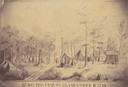
| Date: | 1862 |
|---|---|
| Description: | Sketch of the camp of the 15th Regiment of the Wisconsin Volunteer Infantry on Island No. 10 during the Civil War. Colonel Hans Christian Heg commanded the... |

| Date: | 08 12 1943 |
|---|---|
| Description: | Three indigenous boys building a roof out of what appears to be palm fronds at Combat Team Headquarters on Kiriwina Island, in the Solomon Sea, New Guinea ... |
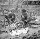
| Date: | 08 12 1943 |
|---|---|
| Description: | Two indigenous boys peel yams on Kiriwina Island, in the Solomon Sea, New Guinea (present day Papua New Guinea). |

| Date: | 08 13 1943 |
|---|---|
| Description: | Major Howard Pagel of Ladysmith, Wisconsin, poses for a photo on Kiriwina Island in the Solomon Sea, New Guinea (present day Papua New Guinea). Notes by Ro... |
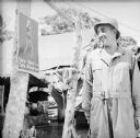
| Date: | 08 15 1943 |
|---|---|
| Description: | Private Leopold Blaha, a barber from Milwaukee, Wisconsin, looks at a poster with a pretty woman depicted on it that urges the soldiers to take their Atabr... |
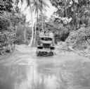
| Date: | 08 15 1943 |
|---|---|
| Description: | Three soldiers in a truck drive through mud on Kiriwina Island in the Solomon Sea, New Guinea (present day Papua New Guinea). Jungle foliage is in the back... |

| Date: | 08 16 1943 |
|---|---|
| Description: | Five indigenous workers balance on timbers while building the framing for a roof on Kiriwina Island in the Solomon Sea, New Guinea (present day Papua New G... |

| Date: | 08 18 1943 |
|---|---|
| Description: | Corporal Marcell Vanden Heuval, from Grand Rapids, Michigan, poses with his coati named "Speedy" perched on his shoulder. He was a cook at the military cam... |
| Date: | 08 19 1943 |
|---|---|
| Description: | Two soldiers inspect a knife at Kiriwina Beach Camp on Kiriwina Island in the Solomon Sea, New Guinea (present day Papua New Guinea). They are standing in ... |
| Date: | 08 20 1943 |
|---|---|
| Description: | Four soldiers from Wisconsin look at a cat held by an indigenous man on Kiriwina Island in the Solomon Sea, New Guinea (present day Papua New Guinea). Name... |
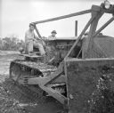
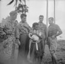
| Date: | 08 22 1943 |
|---|---|
| Description: | Corporal Eugene Cierzynski of Milwaukee, Wisconsin (left) instructs Corporal Edgar Hourscht of Trosky, Minnesota (right), on how to operate a D-8 Caterpill... |
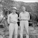
| Date: | 08 22 1943 |
|---|---|
| Description: | Major Howard Pagel (left) of Ladysmith, Wisconsin, and Captain Walter King (right) of Waco, Texas, stand together in front of the airfield aid station at t... |
| Date: | 08 22 1943 |
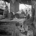
|---|---|
| Description: | The sawmill for the engineers at the military camp on Kiriwina Island in the Solomon Sea, New Guinea (present day Papua New Guinea). The soldiers are just ... |

| Date: | 08 24 1943 |
|---|---|
| Description: | An indigenous man climbs a coconut palm to harvest coconuts on Kiriwina Island in the Solomon Sea, New Guinea (present day Papua New Guinea). His feet are ... |

| Date: | 08 28 1943 |
|---|---|
| Description: | View looking up at an upset indigenous toddler wearing a banner around his middle with "1944" pasted on it. He is holding a pair of sunglasses and standing... |

| Date: | 08 24 1943 |
|---|---|
| Description: | An indigenous woman wearing a grass shirt sits on a carved boat with Robert Doyle on the shore of Kiriwina Island in the Solomon Sea, New Guinea (present d... |
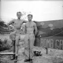
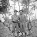
| Date: | 08 29 1943 |
|---|---|
| Description: | Two Wisconsin cousins, (left) Corporal Englund Johnson, bomber waist gunner, of Park Falls and (right) Sergeant Donald Englund, airplane engine mechanic, o... |

| Date: | 10 1776 |
|---|---|
| Description: | Broadside map showing the British invasion of New York city in August and September of 1776. The map shows important cities, forts, roads, hills, mountains... |

| Date: | 02 1777 |
|---|---|
| Description: | Map depicting the campaigns of October and November 1776, in Manhattan, Westchester, and part of New Jersey, published only a few months after the conclusi... |

| Date: | 03 1777 |
|---|---|
| Description: | Map showing the British and Hessian attack on Fort Washington in November of 1776. The movements and fortifications of the British and Hessian troops appea... |
If you didn't find the material you searched for, our Library Reference Staff can help.
Call our reference desk at 608-264-6535 or email us at: