 Filter: Categories of Wisconsin Historical Images
Filter: Subject of Islands
Filter: Subject of land use, rural
Filter: Categories of Wisconsin Historical Images
Filter: Subject of Islands
Filter: Subject of land use, rural
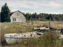
| Date: | 08 24 1964 |
|---|---|
| Description: | Shore scene at end of Main Road showing studio and small boats at low water. |

| Date: | 1850 |
|---|---|
| Description: | Pastoral scene depicting a small bay on the Island of St. Ignace in Lake Superior with canoes on the rocky beach, two men conversing on a blanket in the fo... |

| Date: | 1875 |
|---|---|
| Description: | Aerial view of Alma along Mississippi River, with bluffs along the horizon. |
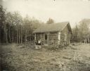
| Date: | 1914 |
|---|---|
| Description: | Log cabin known as the "haunted house" on Rock Island, remodeled by Chester Thordarson. There are three people sitting on the porch. |

| Date: | 1829 |
|---|---|
| Description: | Hand-colored lithograph of Fort Armstrong on Rock Island, based on a drawing by Henry Lewis. Foreground shows a tree floating in the water. |

| Date: | 1829 |
|---|---|
| Description: | Hand-colored lithograph of Fort Armstrong, based on a drawing by Henry Lewis. Includes boats on the Mississippi River. |

| Date: | |
|---|---|
| Description: | A view looking down a dirt road, surrounded by large trees and smaller palm trees. |
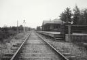
| Date: | |
|---|---|
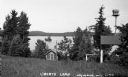
| Description: | View down railroad tracks which pass the Miscauno Island depot. A railroad signal is on the left, and the platform for the depot is on the right. |

| Date: | 07 01 1954 |
|---|---|
| Description: | Sigurd Olson, followed by Tony Lovink, at the beginning of their "grand portage." A large lake and islands are in the background. |
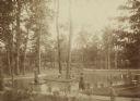
| Date: | 1888 |
|---|---|
| Description: | Several adults, two children and a dog enjoying a pond at Bracken Brae, the country home of John Johnston (1836-1904), a successful Milwaukee banker. Hilda... |
| Date: | 1935 |
|---|---|
| Description: | Small shack on shore of Little Spider Lake. Sign over door reads: "The Compleat Angler." There is a shelter made of birch tree trunks that has a birdhouse ... |

| Date: | 1782 |
|---|---|
| Description: | Map of the West Indies and south eastern North America, remarkably detailed, showing cities, mountains, rivers, lakes, mines, plantations, forts, banks, an... |

| Date: | 1755 |
|---|---|
| Description: | Map of Virginia and parts of Maryland, North Carolina, and New Jersey. It shows borders, boundary lines, some Native American land, counties, cities, towns... |

| Date: | 1776 |
|---|---|
| Description: | Map of Virginia and parts of Maryland and Delaware (written "De La War"). It shows borders, counties, cities, towns, plantations (marked by landowners name... |

| Date: | 1793 |
|---|---|
| Description: | Detailed topographical map of the Ohio River between Clarkville and Louisville. It shows plots of farmland, forest, islands, garden plots, houses, Fort Fe... |
If you didn't find the material you searched for, our Library Reference Staff can help.
Call our reference desk at 608-264-6535 or email us at: