 Filter: Categories of Wisconsin Historical Images
Filter: Subject of International relations
Filter: Subject of persons
Filter: Categories of Wisconsin Historical Images
Filter: Subject of International relations
Filter: Subject of persons

| Date: | 11 15 1989 |
|---|---|
| Description: | Congressman David Obey and Chairman of Solidarity Lech Walesa of Poland shake hands. |
| Date: | |
|---|---|
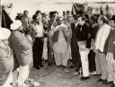
| Description: | Congressman David Obey outdoors in a group of men listening to a speaker in the Middle East. They are surrounded by tents. |

| Date: | 12 08 1961 |
|---|---|
| Description: | A woman is holding a doll while standing in front of a display of dolls and stuffed animals. |

| Date: | 04 04 1964 |
|---|---|
| Description: | A Scandinavian trade delegation of 25 Norwegian businessmen and journalists visits Madison to publicize the inaugural flight of Scandinavian Airlines Syste... |

| Date: | 04 04 1964 |
|---|---|
| Description: | A Scandinavian trade delegation of 25 Norwegian businessmen and journalists visit Madison to publicize the inaugural flight of Scandinavian Airlines System... |

| Date: | 06 30 1964 |
|---|---|
| Description: | Esen Ozgen, an American Field Service student from Turkey, cries while saying her goodbyes to her Madison friends before leaving to tour the eastern states... |

| Date: | 03 02 1965 |
|---|---|
| Description: | A crowd of about 200 people are gathering in front of the U.W. Memorial Union at a U.W. sponsored rally in support of the United Nations. The accompanying ... |

| Date: | 04 24 1939 |
|---|---|
| Description: | Princess Ingrid of Denmark with Wisconsin Governor Julius Heil. The princess is wearing a floral patterned short sleeved dress, a pearl necklace, earrings,... |

| Date: | 07 1980 |
|---|---|
| Description: | Vel Phillips, on the left, sitting with two other woman at a table. They are all wearing name tags. Other women sit at tables behind them. |

| Date: | 10 30 1965 |
|---|---|
| Description: | Critics and supporters of the United States policy in Viet Nam discuss their views at a meeting of the policy committee of the University of Wisconsin Youn... |

| Date: | 10 30 1965 |
|---|---|
| Description: | Critics and supporters of the United States policy in Viet Nam discuss their views at a meeting of the policy committee of the University of Wisconsin Youn... |

| Date: | 1715 |
|---|---|
| Description: | One of Herman Moll's most famous maps, often referred to as The Codfish Map, it shows rivers and portages, cities, Indian villages, wind directions, routes... |

| Date: | 1746 |
|---|---|
| Description: | Map of North America from the southern portion of James Bay to Florida. It shows the colonies, cities, Native American land, and topological and geographic... |

| Date: | 1758 |
|---|---|
| Description: | This map of the north-west hemisphere shows the cities, lakes, rivers, mountains, and political borders. In the upper left corner sits a decorative cartouc... |

| Date: | 1755 |
|---|---|
| Description: | This map shows the eastern half of North America during the French and Indian war, including cities, borders, Native American Land, forts, and detailed geo... |

| Date: | 1783 |
|---|---|
| Description: | This map is hand-colored and shows the boundaries of British, Spanish, and the newly recognized American claims, as well as the fishing rights granted to F... |

| Date: | |
|---|---|
| Description: | Profile portrait of bald-headed man wearing a pair of eyeglasses with a cannon in place of his nose. At the top the text reads: "Arms For Sale," and at the... |

| Date: | 1780 |
|---|---|
| Description: | Map of North and South America, showing the boundaries of colonial territories, cities, settlements, rivers, lakes, and Native American land. Particular em... |

| Date: | 1710 |
|---|---|
| Description: | Map of North America showing the European claims, Native American land and villages, rivers, lakes, cities, and notes on explorers, discoveries, and topogr... |

| Date: | 1719 |
|---|---|
| Description: | Map of North America showing land divisions between France, Spain, England, Sweden, Denmark and Holland. The map is detailed, labeling cities, forts, islan... |
If you didn't find the material you searched for, our Library Reference Staff can help.
Call our reference desk at 608-264-6535 or email us at: