 Filter: Categories of Wisconsin Historical Images
Filter: Subject of International relations
Filter: Subject of land use
Filter: Categories of Wisconsin Historical Images
Filter: Subject of International relations
Filter: Subject of land use
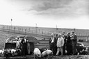
| Date: | 1959 |
|---|---|
| Description: | Soviet Premier Nikita Khrushchev inspecting hogs on a farm. Khrushchev is accompanied by Roswell "Bob" Garst and Ambassador Henry Cabot Lodge. |

| Date: | |
|---|---|
| Description: | Officials greet one another in front of Boundary Monument 258 between the United States and Mexico. A protective fence is behind the men. |
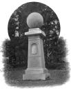
| Date: | |
|---|---|
| Description: | Also known as the monument to "The Birthplace of American Foreign Missions," the Haystack Monument was erected in 1867 by William College's Society of Alum... |
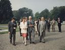
| Date: | 1991 |
|---|---|
| Description: | Mary Robinson, President of Ireland, escorting Speaker of the House of Representative Thomas Foley, who was heading a house leadership trip to Ireland. To ... |

| Date: | 1715 |
|---|---|
| Description: | A map of the countries and islands surrounding the Gulf of Mexico. The hand-colored borders separate the territories of England, France, Spain, and Holland... |

| Date: | 1782 |
|---|---|
| Description: | Map of the West Indies and south eastern North America, remarkably detailed, showing cities, mountains, rivers, lakes, mines, plantations, forts, banks, an... |

| Date: | 1758 |
|---|---|
| Description: | This detailed map of north eastern America shows the boundaries, cities, mountains, rivers, lakes, Native American land and towns, and roads from east of t... |

| Date: | 1760 |
|---|---|
| Description: | Map showing the towns, mountains, valleys, corn fields, and rivers of a portion of the Cherokee Nation. A few annotations on the map explain the land and r... |
If you didn't find the material you searched for, our Library Reference Staff can help.
Call our reference desk at 608-264-6535 or email us at: