 Filter: Categories of Wisconsin Historical Images
Filter: Subject of International relations
Filter: Subject of arts
Filter: Categories of Wisconsin Historical Images
Filter: Subject of International relations
Filter: Subject of arts

| Date: | 11 04 1949 |
|---|---|
| Description: | Elevated view of a large crowd of people gathered on the University of Wisconsin Union Terrace to listen to a speech by Prime Minister Pandit Jawaharlal Ne... |

| Date: | 09 12 1950 |
|---|---|
| Description: | Newcomers from other countries were special guests at a benefit garden tea, hosted by the World Fellowship Committee at the YWCA. Mrs. Tatiana Pronin, 292... |
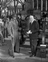
| Date: | 10 24 1950 |
|---|---|
| Description: | Corporal Albert Griffin, a soldier from Milwaukee wounded in the Korean War, standing with Governor Rennebohm at the freedom bell during ceremonies at the ... |

| Date: | |
|---|---|
| Description: | Ben Bergor, Madison magician, ventriloquist, and entertainment agent, performing with Jerry O'Reilly at a farm show. With Bergor is his wife Alva who often... |

| Date: | 1910 |
|---|---|
| Description: | Ben Goldenberger and his sister Olivia face each other over a small table. There is a menorah on the bookcase in the background. Ben would later change his... |

| Date: | 1980 |
|---|---|
| Description: | Congressman David R. Obey of Wisconsin (far left) meeting President Muhammad Zia-ul-Haq during a visit to Pakistan. |
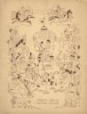
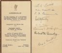
| Date: | 02 02 1951 |
|---|---|
| Description: | Front cover of the menu and program for the Fifth Anniversary of the Secretary-Generalship of Trygve Lie, first Secretary-General of the United Nations (UN... |
| Date: | 11 27 1950 |
|---|---|
| Description: | Front cover of the menu for a dinner given by Nazrollah Entezam, President of the United Nations (UN) General Assembly during its fifth session and leader ... |
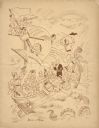
| Date: | 02 26 1942 |
|---|---|
| Description: | Front cover and menu page from the program for the Third Annual Dinner of the Overseas Press Club of America for Anti-Axis Solidarity, with an illustration... |
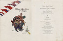
| Date: | 06 28 1948 |
|---|---|
| Description: | Front and back sides of a one-page luncheon menu commemorating the signing of a bilateral agreement between Ireland and the United States that allowed Irel... |

| Date: | 1715 |
|---|---|
| Description: | A map of the countries and islands surrounding the Gulf of Mexico. The hand-colored borders separate the territories of England, France, Spain, and Holland... |

| Date: | 1739 |
|---|---|
| Description: | This map shows the territorial claims of the western hemisphere by the European powers, as well as the names of major cities, geographical features, and pa... |

| Date: | 1746 |
|---|---|
| Description: | A map of the western hemisphere, including parts of western Europe and Africa, showing the division of the Americas by the European powers. Weapons and fol... |

| Date: | 1720 |
|---|---|
| Description: | One of Herman Moll's most famous maps, often referred to as The Beaver Map for its elaborate engraved inset depicting and describing beavers building a dam... |

| Date: | 1715 |
|---|---|
| Description: | One of Herman Moll's most famous maps, often referred to as The Codfish Map, it shows rivers and portages, cities, Indian villages, wind directions, routes... |

| Date: | 1720 |
|---|---|
| Description: | This map of North America shows cities, rivers, lakes, and a few topographical features, complete with numerous descriptive blocks of text about expedition... |

| Date: | 1746 |
|---|---|
| Description: | Map of North America from the southern portion of James Bay to Florida. It shows the colonies, cities, Native American land, and topological and geographic... |

| Date: | 1758 |
|---|---|
| Description: | This map of the north-west hemisphere shows the cities, lakes, rivers, mountains, and political borders. In the upper left corner sits a decorative cartouc... |

| Date: | 1755 |
|---|---|
| Description: | This map shows forts, missions, villages and cities, rivers and portages, and boundaries of the Spanish, English, and French territories, marking the large... |

| Date: | 1757 |
|---|---|
| Description: | This map shows the cities, plantations, lakes, rivers, mountains, Native American territories and colonial borders of the Eastern half of North America, pl... |
If you didn't find the material you searched for, our Library Reference Staff can help.
Call our reference desk at 608-264-6535 or email us at: