 Filter: Categories of Wisconsin Historical Images
Filter: Subject of International relations
Filter: Subject of animals
Filter: Categories of Wisconsin Historical Images
Filter: Subject of International relations
Filter: Subject of animals
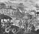
| Date: | 1655 |
|---|---|
| Description: | Scene from the Vespucci Expedition, 1499. |

| Date: | 02 25 1971 |
|---|---|
| Description: | Poster advertising the Model United Nations at the University of Wisconsin-Madison. Features a dove with an olive branch as a symbol of peace. |

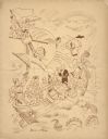
| Date: | 1917 |
|---|---|
| Description: | Man identified in original caption as "Mr. Duncan" on board the ship Buffalo as part of the Root Commission's trip to Russia. A goat appears to be l... |
| Date: | 02 02 1951 |
|---|---|
| Description: | Front cover of the menu and program for the Fifth Anniversary of the Secretary-Generalship of Trygve Lie, first Secretary-General of the United Nations (UN... |
| Date: | 11 27 1950 |
|---|---|
| Description: | Front cover of the menu for a dinner given by Nazrollah Entezam, President of the United Nations (UN) General Assembly during its fifth session and leader ... |

| Date: | 1720 |
|---|---|
| Description: | One of Herman Moll's most famous maps, often referred to as The Beaver Map for its elaborate engraved inset depicting and describing beavers building a dam... |

| Date: | 1715 |
|---|---|
| Description: | One of Herman Moll's most famous maps, often referred to as The Codfish Map, it shows rivers and portages, cities, Indian villages, wind directions, routes... |

| Date: | 1746 |
|---|---|
| Description: | Map of North America from the southern portion of James Bay to Florida. It shows the colonies, cities, Native American land, and topological and geographic... |

| Date: | 1758 |
|---|---|
| Description: | This map of the north-west hemisphere shows the cities, lakes, rivers, mountains, and political borders. In the upper left corner sits a decorative cartouc... |

| Date: | 1783 |
|---|---|
| Description: | This map is hand-colored and shows the boundaries of British, Spanish, and the newly recognized American claims, as well as the fishing rights granted to F... |

| Date: | 1780 |
|---|---|
| Description: | Map of North and South America, showing the boundaries of colonial territories, cities, settlements, rivers, lakes, and Native American land. Particular em... |

| Date: | 1719 |
|---|---|
| Description: | Map of the Great Lakes and the St. Lawrence river showing French and English cities and villages, trading posts, Indian villages and tribes, portages, for... |

| Date: | 1719 |
|---|---|
| Description: | Map of North America showing land divisions between France, Spain, England, Sweden, Denmark and Holland. The map is detailed, labeling cities, forts, islan... |

| Date: | 1766 |
|---|---|
| Description: | This map of North America shows the boundaries of European claims at the end of the French and Indian war. The British colonies extend to the Mississippi. ... |

| Date: | 1733 |
|---|---|
| Description: | This map of North America shows settlements, rivers, lakes, Native American land, trade winds, and numerous topographical features such as forests and moun... |

| Date: | 1758 |
|---|---|
| Description: | Map showing lakes, rivers, cities, Native American land, and the boundaries of French and English claims in America and Canada north of New York. A title c... |

| Date: | 1765 |
|---|---|
| Description: | Detailed map composed for the London Magazine of the Mississippi River Valley at the conclusion of the French and Indian War. The British colonies themselv... |

| Date: | 1783 |
|---|---|
| Description: | Map of the newly formed United States showing borders, regions, Native American land, cities, mountains, lakes, and rivers. It includes a small inset map o... |
If you didn't find the material you searched for, our Library Reference Staff can help.
Call our reference desk at 608-264-6535 or email us at: