 Filter: Categories of Wisconsin Historical Images
Filter: Subject of Indian reservations
Filter: Type of Map or Atlas
Filter: Categories of Wisconsin Historical Images
Filter: Subject of Indian reservations
Filter: Type of Map or Atlas

| Date: | 1890 |
|---|---|
| Description: | This 1890s map shows the Wisconsin Central Railroad land grant lands owned and for sale by the Soo Line in Ashland County, Wisconsin, as well as in the eas... |
| Date: | 1915 |
|---|---|
| Description: | This early 20th century map highlights the land for sale by the American Immigration Company, Chippewa Falls, Wisconsin, in the towns of Cable, Drummond, G... |
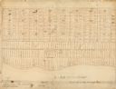
| Date: | |
|---|---|
| Description: | This map, which was likely drawn in the mid-19th century, shows land ownership on the Stockbridge Reservation on the shore of Lake Winnebago in what is now... |

| Date: | 1974 |
|---|---|
| Description: | This 1968 map identifies resorts in the Lac du Flambeau Indian Reservation region of Wisconsin, covering parts of Iron, Vilas, Oneida, and Price counties. ... |

| Date: | 1898 |
|---|---|
| Description: | This 1898 map of Ashland County, Wisconsin, shows the township and range grid, towns, sections, cities and villages, landownership, roads, railroads, swamp... |

| Date: | 1896 |
|---|---|
| Description: | This map of Brown County, Wisconsin, from the late 19th century shows land claims along the Fox River, the township and range grid, towns, sections, cities... |

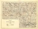
| Date: | 1911 |
|---|---|
| Description: | This 1911 map of the geology of northern Wisconsin between Superior and Hurley was published by the Wisconsin Geological and Natural History Survey in Fred... |

| Date: | 1873 |
|---|---|
| Description: | This 1873 map of Chippewa County, Wisconsin, which at the time also encompassed all or part of Price, Rusk, Sawyer, and Taylor counties, shows the township... |

| Date: | 1895 |
|---|---|
| Description: | This late 19th century map of northern Wisconsin and a portion of Michigan's Upper Peninsula shows the township and range grid, the (Lac du) Flambeau India... |

| Date: | 1909 |
|---|---|
| Description: | This 1909 map of northern Wisconsin and a portion of Michigan's Upper Peninsula shows the Lac du Flambeau Indian Reservation, cities and villages, railroad... |
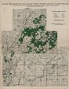
| Date: | 1929 |
|---|---|
| Description: | Map of the Menominee Indian Reservation. Legend reads: "Topographic and cultural data were obtained from field notes of a timber cruise and land classifica... |

| Date: | 1915 |
|---|---|
| Description: | This map shows school houses, churches, farms, and railroads. Chequamecon Bay and Bad River Indian Reservation are labeld. The map reads: "All lands shown ... |

| Date: | 1935 |
|---|---|
| Description: | This topographical map of the forest preserve shows highways, roads, trails, telephone lines, Native American reservations, Ranger sub-stations, state nurs... |

| Date: | 1909 |
|---|---|
| Description: | This map shows vacant Wisconsin Central Ry. lands, settlers houses, lands sold by Wisconsin Central Ry., schools, churches, saw mills, and roads; also show... |

| Date: | 1939 |
|---|---|
| Description: | This illustrated map shows counties, highways, rivers, roads, present and proposed state parks and forests, proposed state parkways, proposed state monumen... |

| Date: | 1956 |
|---|---|
| Description: | This map shows reservation boundaries, U.S. township lines, highways, roads, rivers, and lakes. The lower left corner of the map includes a legend of "Conv... |

| Date: | 1853 |
|---|---|
| Description: | This map shows camps, forts, logging camps, lakes, roads, railroads, the Wisconsin River, and Lac Du Flambeau Indian Reservation. Some points of interest a... |

| Date: | 1969 |
|---|---|
| Description: | This map shows ghost towns, Indian reservations, lakes, railroads, and rivers. Ghost towns are numbered and listed in a corresponding index. |

| Date: | 1911 |
|---|---|
| Description: | This map shows swamps, railroads, rivers, roads, the Catholic Mission Reserve, the day school, and the Agency Reserve. Lake Superior is labeled. An inset m... |

| Date: | 1911 |
|---|---|
| Description: | This map shows lakes, rivers, swamps, state swamp land, trails and railroads. Includes a township diagram. |
If you didn't find the material you searched for, our Library Reference Staff can help.
Call our reference desk at 608-264-6535 or email us at: