Filter: Categories of Wisconsin Historical Images
Filter: Subject of Hunting
Filter: Subject of boats and boating
Filter: Categories of Wisconsin Historical Images
Filter: Subject of Hunting
Filter: Subject of boats and boating

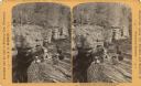
| Date: | 1870 |
|---|---|
| Description: | Bird's-eye view of Whitewater, with insets. |
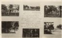
| Date: | 07 02 1925 |
|---|---|
| Description: | Photographic postcard of a poster promoting Camp Milo on White Sand Lake. On it are photographs of the cabins, tents, lake, and boats on the shore. |
| Date: | |
|---|---|
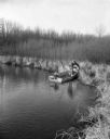
| Description: | A hunter, sporting cold weather attire and thigh-high rubber boots, pulls a mink in a trap off the shoreline and on to his small, motorized, fishing boat. ... |
| Date: | |
|---|---|
| Description: | Elevated view of two men sitting on the side of a rock formation. The man on the right is holding a rifle and a stringer of squirrels. The man on the left ... |
| Date: | |
|---|---|
| Description: | The boss says — The center is — Good workmen then served two masters One a man, the other a craft A fine-edged tool biting life-long in... |

| Date: | 1910 |
|---|---|
| Description: | Group of twelve men and one boy posing on a dock. A dog lays at the feet of the man in the center. Three of the men hold stringers of dead ducks. On the fa... |
| Date: | 1910 |
|---|---|
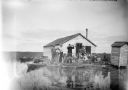
| Description: | View across water towards a group of seven men posing on a dock in front of a small hunting shack in the middle of a marsh. Ducks hang on stringers attache... |

| Date: | 1918 |
|---|---|
| Description: | Manuscript map of the Chequamegon Bay area on Lake Superior drawn by Warren W. Witmer and illustrated with sketches by Mary L. Wright Witmer in ink and wat... |

| Date: | 1959 |
|---|---|
| Description: | This map shows public access sites, public beaches and parks, other public shorelines, boat liveries, public hunting and fishing grounds, railroads, roads,... |

| Date: | 1960 |
|---|---|
| Description: | This pictorial map shows recreation activities, rivers, lakes, and the history of the area. The map covers Langlade County and parts of adjacent counties. ... |

| Date: | 1960 |
|---|---|
| Description: | This map shows improved town roads, federal highways, county highways, public boat access, public hunting areas, railroads, and lakes in the area around th... |

| Date: | 1949 |
|---|---|
| Description: | This multi-colored promotional map for recreational activities in the Hayward area includes a graphic of distances from Midwestern cities to Hayward, with ... |
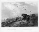
| Date: | 1858 |
|---|---|
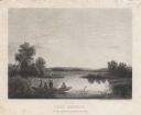
| Description: | Engraved print of four men and a dog in a boat on Lake Winnebago. Two of the men are in the center of the boat holding hunting rifles, while one man is sta... |

| Date: | 1906 |
|---|---|
| Description: | An unidentified woman, wearing a hat and standing in a skiff is aiming a gun toward the shore of the mill pond (Montello Lake). The printed inscription on ... |

| Date: | 1908 |
|---|---|
| Description: | View of a marshy part of Rock Lake. Two small rowboats and a pile of logs are on the shore, and a flock of ducks is in the water. Caption reads: "Hunting G... |

| Date: | 10 10 1936 |
|---|---|
| Description: | As described on the negative envelope, an unidentified man is standing in his boat, "Shooting at a flock of mallards at Lake Partridge near Fremont on the ... |
If you didn't find the material you searched for, our Library Reference Staff can help.
Call our reference desk at 608-264-6535 or email us at: