Map or Atlas
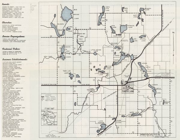
Turtle Lake, Wisconsin: Dairyland's Gateway to Vacation Land

| This map shows improved town roads, federal highways, county highways, public boat access, public hunting areas, railroads, and lakes in the area around the village of Turtle Lake, in parts of Polk and Barron Counties. Includes lists of resorts, churches, service organization, fraternal orders, business establishments in the left hand margin. Original caption on the back reads: "Turtle Lake, situated between Barron and Polk, two of Wisconsin's foremost dairy counties, in bounteously endowed by Nature and offers the best in natural recreational opportunities for residents and visitors of this area." Includes text blocks about fishing, hunting, industry and community history. Photographs and illustrations are seen throughout the back of the map. |
| Image ID: | 120807 |
|---|---|
| Creation Date: | circa 1960 |
| Creator Name: | Johnson, Herb |
| City: | Turtle Lake |
| County: | Barron |
| State: | Wisconsin |
| Collection Name: | Map Collection |
| Genre: | Map or Atlas |
| Original Format Type: | prints, photomechanical |
| Original Format Number: | H GX9028 P76 1960 J |
| Original Dimensions: | 42 x 42 cm, on sheet 43 x 55 cm |
| Cities and towns |
| Boats and boating |
| Fishing |
| Hunting |
| Railroads |
| Roads |
| Lakes |
| Rivers |
| This image is issued by the Wisconsin Historical Society. Use of the image requires written permission from the staff of the Collections Division. It may not be sold or redistributed, copied or distributed as a photograph, electronic file, or any other media. The image should not be significantly altered through conventional or electronic means. Images altered beyond standard cropping and resizing require further negotiation with a staff member. The user is responsible for all issues of copyright. Please Credit: Wisconsin Historical Society. |
| Location: | Wisconsin Historical Society Archives, 4th Floor, Madison, Wisconsin |
|---|
