 Filter: Categories of Wisconsin Historical Images
Filter: Subject of Housing
Filter: Year of 1800-1899
Filter: Categories of Wisconsin Historical Images
Filter: Subject of Housing
Filter: Year of 1800-1899
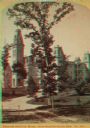
| Date: | 1887 |
|---|---|
| Description: | Stereograph. From the northeast (contrary to photographer's description.) A large tree is standing in the center along the drive, with the home behind it. |
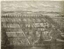
| Date: | 1878 |
|---|---|
| Description: | Engraved view of a house surrounded by gardens, an evergreen shelter belt and ornamental hedges. |

| Date: | 1895 |
|---|---|
| Description: | Valentine's Day card with three layers. The bottom layer is a pink and white card with embossed floral designs. The middle layer (not visible) is a country... |
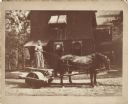
| Date: | 1891 |
|---|---|
| Description: | Julia, the cook, on the rolling machine pulled by a team of horses wearing fly-nets. She is wearing a full-length dress and holding a whip in her right han... |
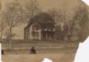
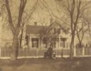
| Date: | 05 14 1887 |
|---|---|
| Description: | The family home of William Henry Rogers on the shore of Lake Mendota. |

| Date: | 1863 |
|---|---|
| Description: | These detailed topographical maps of the Battle of Gettysburg show drainage, vegetation, roads, railroads, fences, houses with names of residents, and a de... |

| Date: | 1870 |
|---|---|
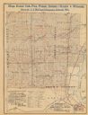
| Description: | A map of Iowa County, Wisconsin mounted on cloth that shows the villages of Avoca, Mifflin, Linden, Arena, Helena Station, Highland, Dodgeville, as well as... |

| Date: | 1898 |
|---|---|
| Description: | A map of Iron County, Wisconsin, shows vacant Wisconsin Central Rail Road lands, settlers houses, land sold by Wisconsin Central R.R., schools, churches, s... |

| Date: | 1842 |
|---|---|
| Description: | Relief shown by hachures. Shows furnaces, saw mills, houses, roads, grist mills, entries, reservations, and diggings. "Compiled by order of the Board of C... |

| Date: | 1857 |
|---|---|
| Description: | Relief shown by hachures. "Lith. of Ed. Mendel, Chicago." Shows townships and sections, rivers, roads, railroads, houses, flour mills, saw mills, furnaces... |

| Date: | 1836 |
|---|---|
| Description: | This map shows settlers houses and businesses, trails, and swamps. The relief is shown by hachures. The map includes illustrations of historical buildings ... |

| Date: | 1890 |
|---|---|
| Description: | Map of Milwaukee as remembered by "Dr Enoch Chase, U.B. Smith & Others." Represented are major roads, lowlands, trails, homesteads, and lots. Map depicts t... |

| Date: | 1840 |
|---|---|
| Description: | Pen-and-ink on paper. Map shows 1840’s homes with owner names, a Native American cemetery, and other points of interest. Relief shown by hachures. Oriented... |
| Date: | 1890 |
|---|---|
| Description: | The map shows roads and railroads, houses, schools, town halls, and other points of interest in parts of Shawano, Oconto, and Brown counties. The lower lef... |
| Date: | 1889 |
|---|---|
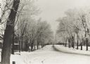
| Description: | Winter scene of North Broadway at Cass Street, De Pere, Wisconsin. Streets are snow covered. |

| Date: | 1899 |
|---|---|
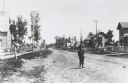
| Description: | Residential street, North Broadway at Cass Street. |
| Date: | 1885 |
|---|---|
| Description: | View of Clermont Street with a young boy in the foreground, homes and trees in the background. Fences and sidewalks line both sides of the street. |
| Date: | 1895 |
|---|---|
| Description: | Pedestrian walking on the snowy street in front of Daniel Fitch Brown's house. |

| Date: | 1880 |
|---|---|
| Description: | Shingled frame residence of A.G. Ellis. Children and adults are posed on the front porch, and on a balcony above. |
| Date: | 1870 |
|---|---|
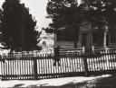
| Description: | View across road of the Clough house, residence of Mr. and Mrs. Willoughby. A man is standing and holding the hands of two young girls in front of the fenc... |
If you didn't find the material you searched for, our Library Reference Staff can help.
Call our reference desk at 608-264-6535 or email us at: