
| Date: | 1910 |
|---|---|
| Description: | Dr. and Mrs. Philip R. and Katherine B. Fox residence at 28 West Wilson Street, corner of South Carroll Street. The house was constructed of Milwaukee bric... |

| Date: | 1898 |
|---|---|
| Description: | University Heights from the Chemistry Building on University Avenue. View includes the University of Wisconsin-Madison football field, on the former site o... |

| Date: | 06 07 1954 |
|---|---|
| Description: | Aerial view of the Midvale neighborhood under construction showing the intersection of Midvale and Tokay Boulevards near the southwestern city limits of Ma... |
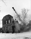
| Date: | 1970 |
|---|---|
| Description: | Historic home on University Avenue being demolished. The home was replaced by Burger King, a fast-food, drive-in restaurant. |
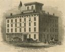
| Date: | 1853 |
|---|---|
| Description: | Illustration of the Capital house, a first-class hotel, copied from page 320 of Gleason's Pictorial Drawing-Room Companion. |
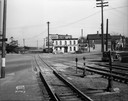
| Date: | 11 12 1936 |
|---|---|
| Description: | Chicago & Northwestern Railroad tracks, looking east at the crossing of S. Blair Street, King Street, E. Wilson Street, and Williamson Street. Included in ... |

| Date: | 1899 |
|---|---|
| Description: | View of home atop of Observatory Hill on the University of Wisconsin-Madison campus. |
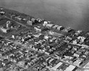
| Date: | 1945 |
|---|---|
| Description: | View of the lower campus of the University of Wisconsin-Madison includes Bascom Hill, Wisconsin Historical Society, Memorial Union and the Armory (Red Gym ... |

| Date: | 1954 |
|---|---|
| Description: | Elevated view of lower Sunset Village looking northwest from Sunset Point. University Hill Farm is on the left and Shorewood Hills is on the right. |

| Date: | 1861 |
|---|---|
| Description: | First block of East Main street photographed from the roof of the Wisconsin State Capitol building. Doty and Wilson street properties and Lake Monona are i... |

| Date: | 1859 |
|---|---|
| Description: | South Pinckney Street as photographed by Fuller from the Wisconsin State Capitol roof. In the center are several wooden structures dating from Madison's e... |

| Date: | 1915 |
|---|---|
| Description: | Exterior view of the Frederick Karberg house located at 25 North Blair Street. The house was later moved to the corner of East Johnson and North Livingston... |
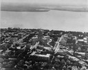
| Date: | 1922 |
|---|---|
| Description: | Aerial view of the Wisconsin State Capitol and Lake Monona. |

| Date: | 1973 |
|---|---|
| Description: | The Bashford House at 423 North Pinckney Street, built in 1857 by Napoleon Bonaparte Van Slyke. |
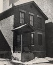
| Date: | 1951 |
|---|---|
| Description: | Exterior view of the Behrend House at 318 North Broom Street, built around 1875 by Nicolas Behrend. |

| Date: | 1929 |
|---|---|
| Description: | Residential block of North Sherman Avenue between McPherson and Farragut Street, across from Sherman School. |

| Date: | 05 1975 |
|---|---|
| Description: | Crowd at the Mifflin Street block party. |

| Date: | |
|---|---|
| Description: | House of Judge Jairus Harvlin Carpenter (1822-1913) at 315 Wisconsin Avenue. |

| Date: | |
|---|---|
| Description: | The Frederick King Conover Residence at 309 North Pinckney Street. |

| Date: | |
|---|---|
| Description: | The Corry-Larkin house, 107 West Gorham Street, built in 1876. After John Corry, Albert Frederickson presumably owned the house and rented it to a Mr. But... |
If you didn't find the material you searched for, our Library Reference Staff can help.
Call our reference desk at 608-264-6535 or email us at: