 Filter: Categories of Wisconsin Historical Images
Filter: Subject of Hospitals
Filter: Subject of parks
Filter: Categories of Wisconsin Historical Images
Filter: Subject of Hospitals
Filter: Subject of parks
| Date: | |
|---|---|
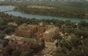
| Description: | Aerial view of the hospital along the banks of a river, with a bridge on the far left. Beyond the river is a baseball park. On the back of the card is writ... |

| Date: | 1910 |
|---|---|
| Description: | Park view featuring two children and their nurse or nanny in the foreground and an inset of the hospital in the upper left corner. Caption reads: "Stoughto... |

| Date: | 1919 |
|---|---|
| Description: | This is a collection of three hand-colored plat maps. One map is a plat plan and includes annotations and an index that shows public land, business, indust... |

| Date: | 1883 |
|---|---|
| Description: | Caption on reverse side of stereograph reads, "Governmental buildings, Wisconsin Conservatory of Music and Hospital over Lake Mendota-looking from Capitol ... |

| Date: | 1910 |
|---|---|
| Description: | End of wing on left is circular. Trees are in front of hospital in a small park area. Caption reads: "St. Mary's Hospital, Milwaukee." |
| Date: | |
|---|---|
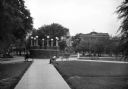
| Description: | A lighted brick platform in Jarvis Plaza with Mercy Hospital in the background. Paved paths lead to the central platform and parkgoers relax on benches. |

| Date: | |
|---|---|
| Description: | A view toward three uniformed men standing on the covered runway to the wards of the United States General Hospital at Roland Park. |

| Date: | 1883 |
|---|---|
| Description: | Caption on reverse side of stereograph reads: "Governmental buildings, Wisconsin Conservatory of Music and Hospital over Lake Mendota-looking from Capitol ... |

| Date: | 1932 |
|---|---|
| Description: | Elevated view of one automobile parked on Main Street. The Legion Memorial Park is across the street. There is a hospital building in the background. Trees... |

| Date: | 1976 |
|---|---|
| Description: | A street map of Milwaukee County, Wisconsin that identifies the location of schools, hospitals, parks, beaches, streets, freeways, both planned or under co... |

| Date: | 1993 |
|---|---|
| Description: | A map of Milwaukee County, indicating the locations of toxic sites and the types of toxic sites, ranging from those listed as a superfund site, industry re... |

| Date: | 1990 |
|---|---|
| Description: | This late 20th century tourist map of Sauk County, Wisconsin, shows the highways and roads, cities and towns, parks, airports, canoe landings, hospitals, s... |

| Date: | 09 04 1957 |
|---|---|
| Description: | A tour guide shows new St. Mary's Hospital School of Nursing students around Madison. Viewing Vilas Park and Lake Wingra are, left to right: Sheila Deseve,... |

| Date: | 1888 |
|---|---|
| Description: | This map has relief shown by hachures and features inset maps of a plat of E.D. Clinton and Blackwell’s add’n to the City of La Crosse. Wards (1-10) shaded... |

| Date: | 04 1905 |
|---|---|
| Description: | Map of the Madison, Wisconsin region showing the four major lakes, starting in the north with Lake Mendota, Lake Monona, Lake Waubesa, and Lake Kegonsa. La... |

| Date: | 1893 |
|---|---|
| Description: | This map shows wards, railroads, street cars, streets, lot and block numbers, landownership, parks, hospitals, the Sheboygan River, and Lake Michigan. Ward... |

| Date: | 1915 |
|---|---|
| Description: | This map shows wards, railroads, street railways, streets, lot and block numbers, parks, and hospitals. Also included are manuscript annotations of points ... |

| Date: | 1956 |
|---|---|
| Description: | This map shows local streets, roads, railroads, highways, parks, cemeteries, hospitals, the University of Wisconsin, Middleton, Maple Bluff, Shorewood Hill... |

| Date: | 1965 |
|---|---|
| Description: | This map shows streets, churches, schools, wards, railroads, parks and fields, cemeteries, Historical Museum, Yacht Basin & Marina, and Marinette General H... |

| Date: | 1879 |
|---|---|
| Description: | This map shows asylums, cemeteries, hospitals, parks, streets, and wards. Relief is shown by contours. Also included are manuscript annotations in pencil. ... |
If you didn't find the material you searched for, our Library Reference Staff can help.
Call our reference desk at 608-264-6535 or email us at: